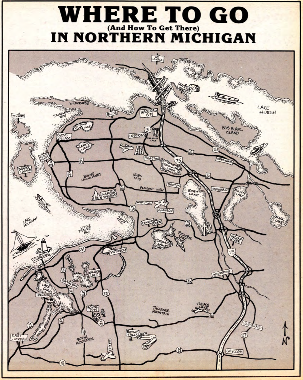
~ MAPS ABOUT WALLOON LAKE ~
Please do not copy the photos on this site, many of which have been submitted by private individuals...
just come back and visit the site often to view the photos.
The design and compilation of the text and photos on this site are copyrighted 2014.
Most posted items will enlarge by "clicking" on them.
"Clicking" on some color highlighted words may access additional information.
just come back and visit the site often to view the photos.
The design and compilation of the text and photos on this site are copyrighted 2014.
Most posted items will enlarge by "clicking" on them.
"Clicking" on some color highlighted words may access additional information.
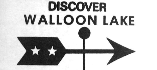
1970s Advertisement to "Discover Walloon Lake" (Previously Bear Lake)
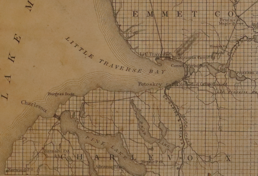
Walloon Lake is surrounded by two counties... Charlevoix County and Emmet County.
Walloon Lake is surrounded by five townships... Melrose, Evangeline, Bay, Resort, and Bear Creek.
~ Maps are included below for each of the counties and townships connected to Walloon Lake. ~
Walloon Lake is surrounded by five townships... Melrose, Evangeline, Bay, Resort, and Bear Creek.
~ Maps are included below for each of the counties and townships connected to Walloon Lake. ~
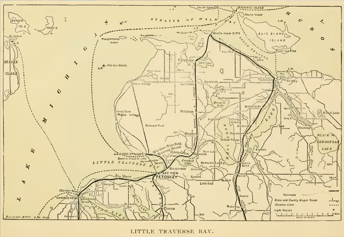
1 April 1896 ~ The Petoskey Record
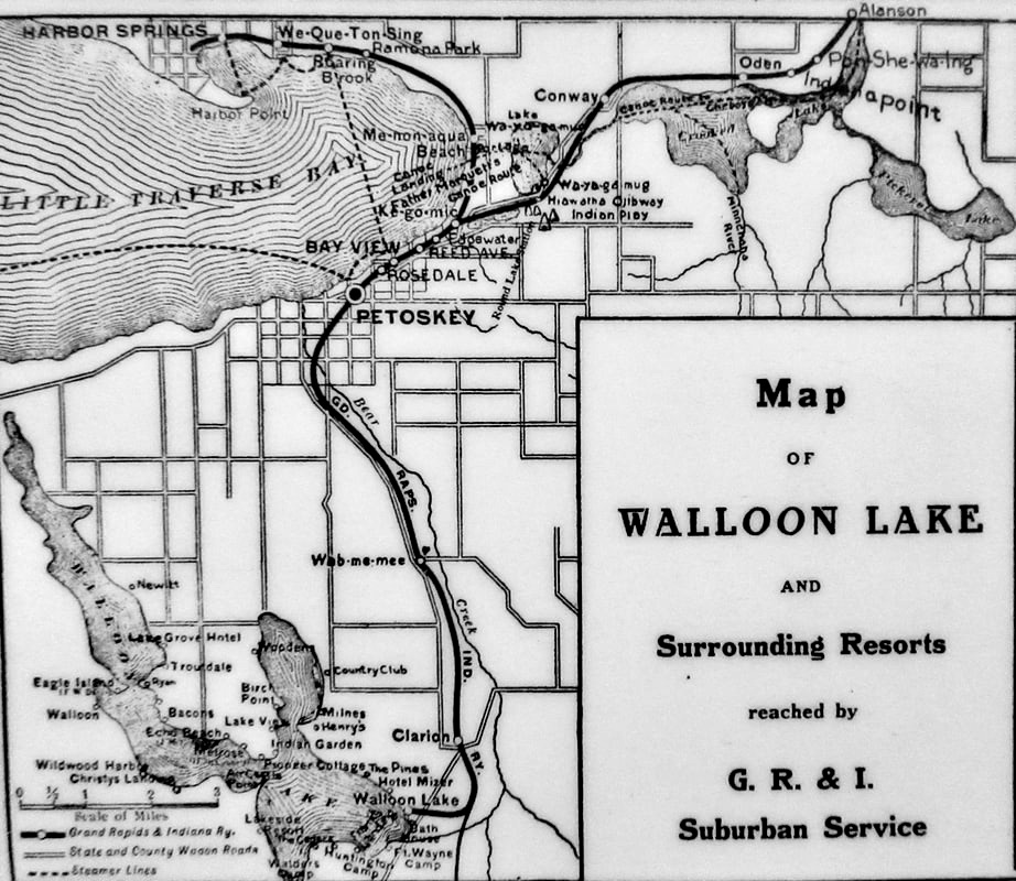
Map Below: Grand Rapids & Indiana Railroad Suburban Service route from Walloon Lake to the Wa-ya-go-mug Hiawatha Ojibway Indian Play. Access additional information on this same Walloon Lake Wanderings web site by clicking HERE.
24 May 2022 ~ Walloon Lake Foot Kiosk
~ Charlevoix County Maps ~
include maps of Melrose Township, Evangeline Township and Bay Township in 1901
include maps of Melrose Township, Evangeline Township and Bay Township in 1901
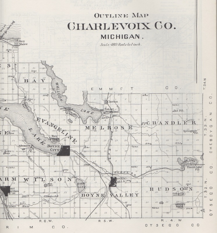
The 1901 Charlevoix County Plat Book shows where Melrose Township, Evangeline Township, and Bay Township touch Walloon Lake.
A survey map measured in 1840 and 1841 of
Melrose Township Charlevoix County MI
1840 Surveyor Charles Cathcart
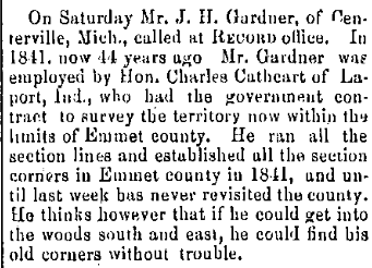
26 August 1885 ~ Petoskey Record
1898 Map with Bear Lake from Hand Book For Travelers Northern Michigan
1898 Map with Bear Lake from Hand Book For Travelers Northern Michigan
19 July 1896 ~ The Daily Resorter
Plat Map of Melrose Township in Charlevoix County
1901
1901
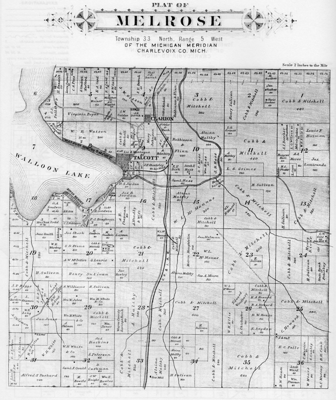
The 1901 Charlevoix County Plat Book shows that Melrose Township then included the Village of Walloon Lake which was then named Talcott.
1901 Plat Map of Talcott, Post Office, including the Village of Walloon Lake
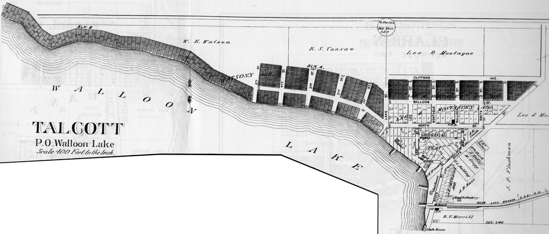
1901 Charlevoix County Plat Book shows that Melrose Township then included the Village of Walloon Lake which was named and platted as Talcott with the Post Office also being Talcott at that time.
1901 Plat Map of Evanageline Township, Charlevoix County,
with small amount of land adjacent to Walloon Lake
with small amount of land adjacent to Walloon Lake
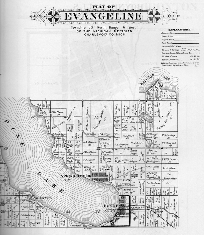
The 1901 Charlevoix County Plat Book shows in the irregularly shaped North-West part of Evangeline Township the very small part where Evangeline Township touches Walloon Lake. Caledonia Heights lies within Evangeline Township.
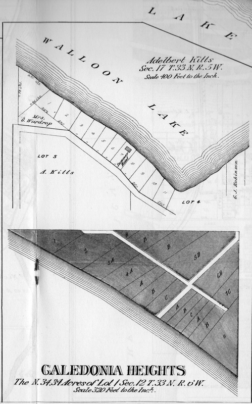
The 1901 Charlevoix County Plat Book shows in the Eveline Township map UP ABOVE this map of Caldonia that the irregularly shaped North-West part of Evangeline Township is a very small part where Evangeline Township touches Walloon Lake. Caledonia Heights shown in the plat above lies within that part of Evangeline Township.
|
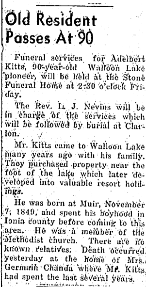
Map Photo Left: Adelbert Kitts owned Lot 5 of Caledonia Heights of Walloon Lake according to the 1901 Charlevoix County Plat Book.
|
1901 Plat Map of Bay Township, Charlevoix County with land adjacent to Walloon Lake
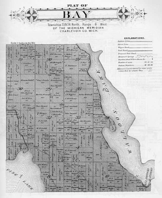
The 1901 Charlevoix County Plat Book shows Bay Township touches Walloon Lake. Bay Township's connection to Walloon Lake includes Wildwood Harbor, close to the west line of Evangeline Township.
1901 Plat Map of Wildwood Harbor, Bay Township, adjacent to Walloon Lake
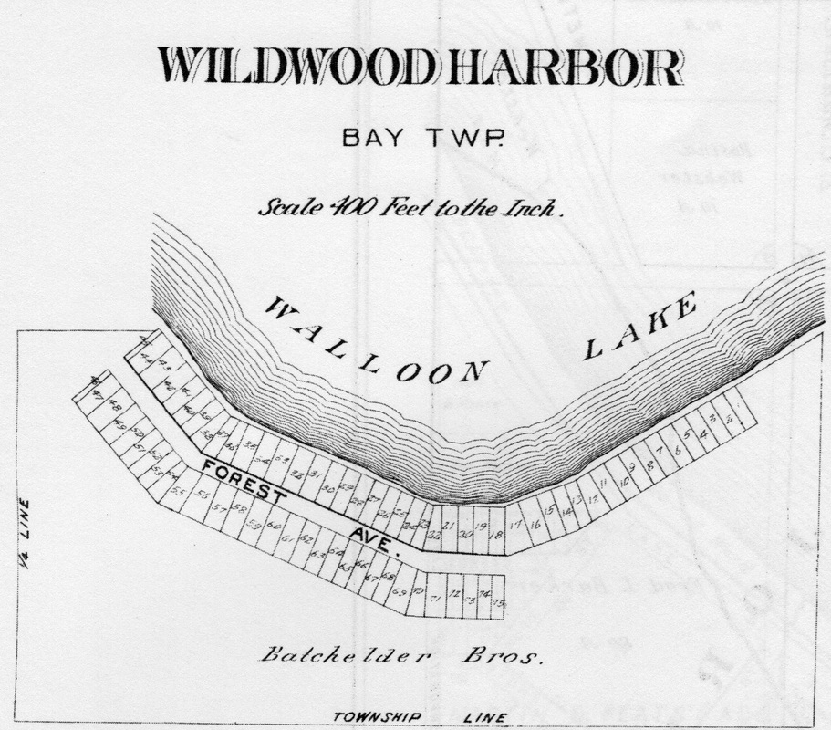
The 1901 Charlevoix County Plat Book shows Bay Township touches Walloon Lake. Bay Township's connection to Walloon Lake includes Wildwood Harbor, close to the west line of Evangeline Township.
1911 Advertising Map of Zenith Heights Lots for Sale on Walloon Lake
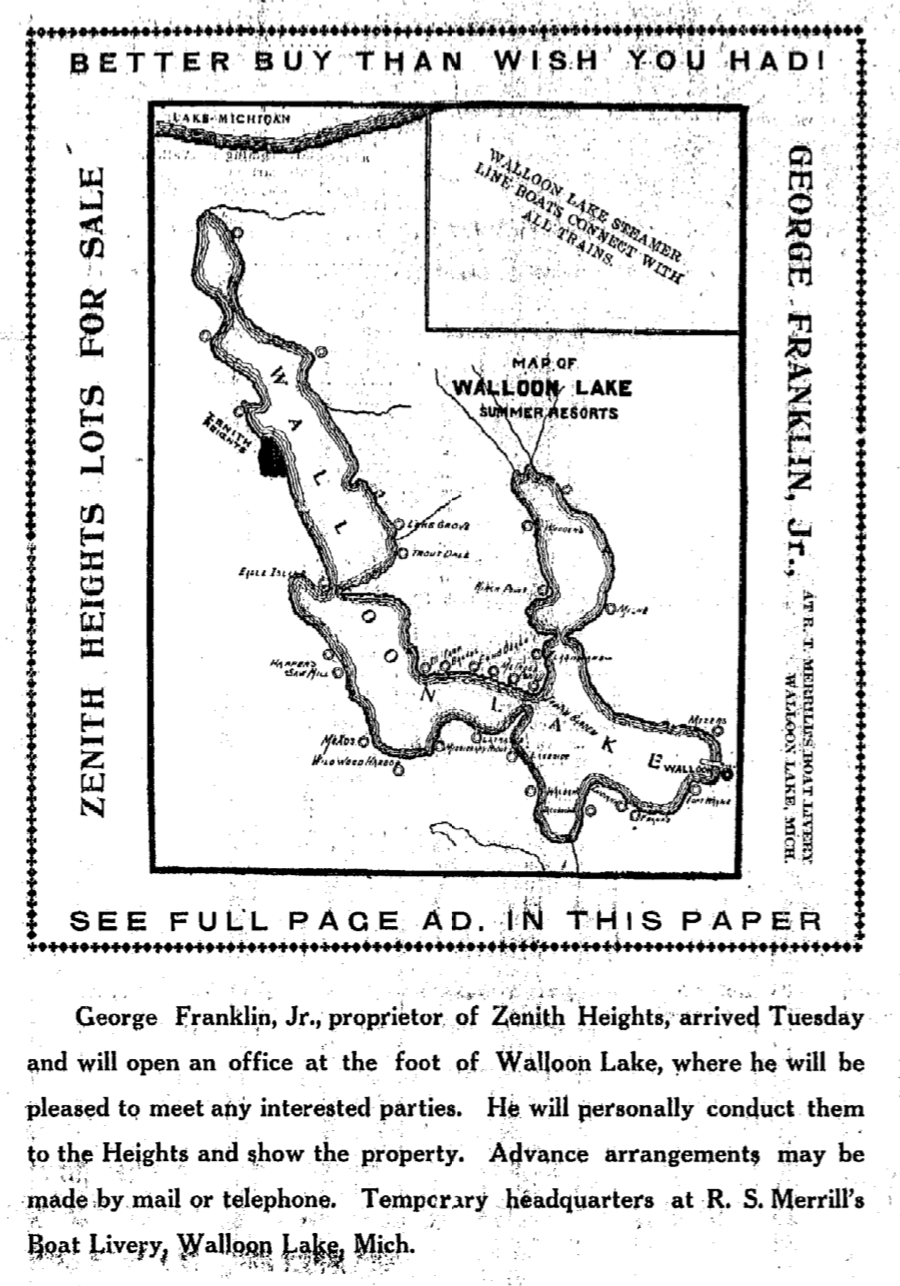
9 August 1911 ~ Petoskey Evening News
Photo of map taken on 24 May 2022, obviously was taken from the 1911 advertisement from above.
24 May 2022 ~ Walloon Lake Foot Kiosk
Click HERE to access NON-COPYRIGHTED Plat Maps of Michigan, like below.
1930>1939 Plat Map of Melrose Township, Charlevoix County, Michigan
1930>1939 Plat Map of Melrose Township, Charlevoix County, Michigan
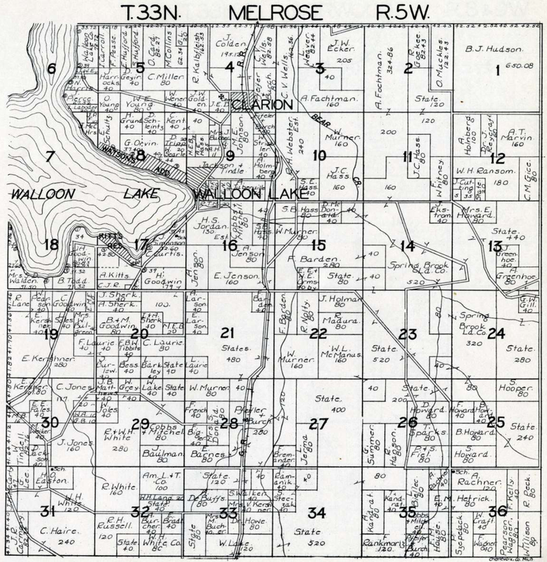
Undated Plat Map of MelroseTownship (Loosely dated 1930 > 1939)
Map Below: Still Capture of an ACTIVE PARCEL MAP SEARCH for Charlevoix County.
The Zoom (+) feature allows for viewing individual parcels which can be clicked
to get individual parcel information. Click HERE to access this site and MAP.
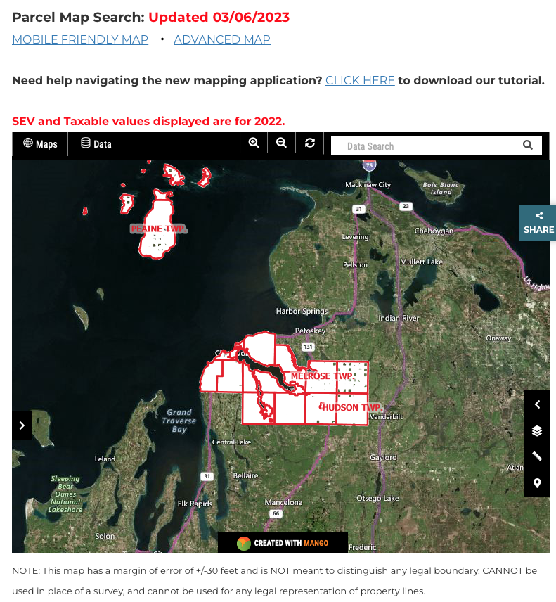
Still Capture on 8 April 2023 of an ACTIVE PARCEL MAP SEARCH for Charlevoix County.
~ Emmet County Maps ~
includes 1902 maps below of Resort Township and Bear Creek Township adjacent to Walloon Lake
includes 1902 maps below of Resort Township and Bear Creek Township adjacent to Walloon Lake
The 1902 Emmet County Plat Book shows where Bear Creek Township and Resort Township touch Walloon Lake.
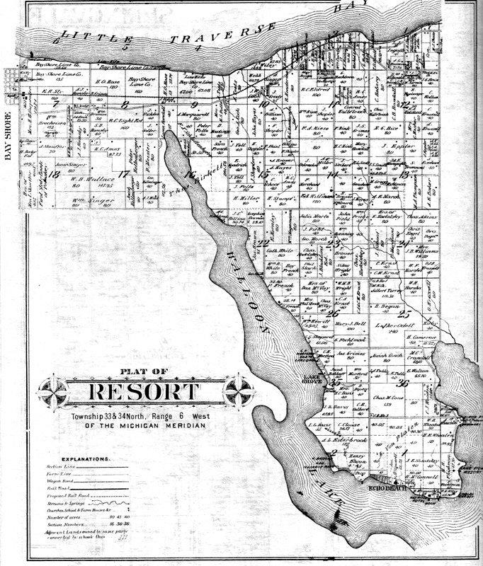
The 1902 Emmet County Plat Book map of Resort Township touches Walloon Lake and shows how close Walloon Lake extends toward Little Traverse Bay in Lake Michigan.
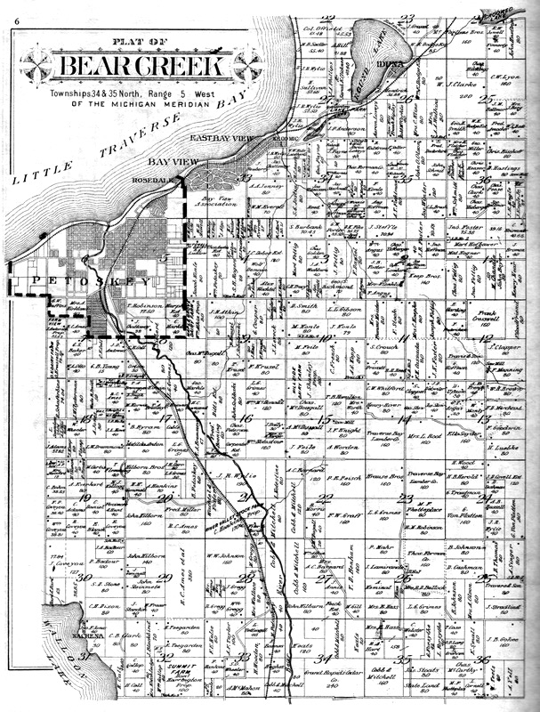
The 1902 Emmet County Plat Book map of Bear Creek Township shows in the South-West corner the small amount of township land that touches Walloon Lake.
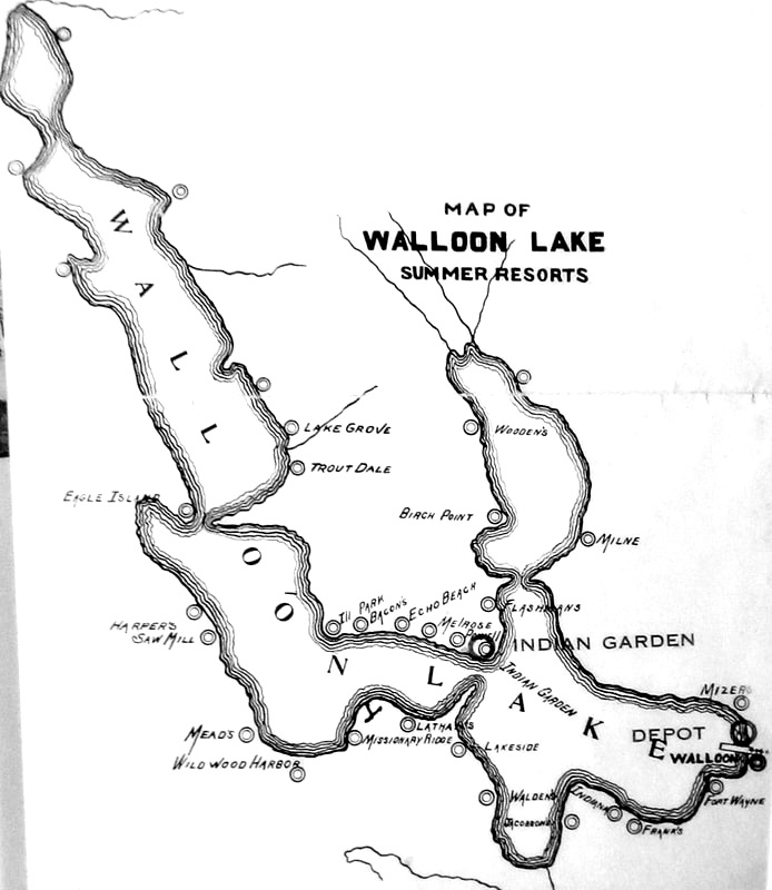
1907 Walloon Lake Map with Points of Interest
1907 ~ Little Traverse Historical Society Map Collection
11 June 1907 LABELS ON MAP ABOVE:
West Arm
Eagle Island
Lake Grove (Hotel)
Trout Dale
PRE-WEST ARM
Bacons
Echo Beach
Illinois Park
Lathams
Melrose
Wildwood Harbor
South Arm
Aircastle Point
Jacobsons
Waldons
South Shore
Beck
Dick
Frank's Hotel & Cottage
Fort Wayne
Indiana Resort
Myers
Purviance
J.H. Smith
Wick
North Shore
Mizers
North Arm
Birch Point
Cellars
Country Club
Gedges
Wheatons
Woodens
Jones
~ 1931 Map #13 of The Archaeological Atlas of Michigan ~
published by the Ann Arbor University of Michigan Press, and written by Wilbert B. Hinsdale
shows a map of Walloon Lake included in Charlevoix County MI.
published by the Ann Arbor University of Michigan Press, and written by Wilbert B. Hinsdale
shows a map of Walloon Lake included in Charlevoix County MI.
~ 1879 Map including Bear Lake (Later, Walloon Lake) ~
Map Below: Section of 1879 Map accessible by clicking HERE
1879 Map including Bear Lake (Walloon Lake) ~ Little Traverse Historical Society Photo Collection
Map Below: 1937: Artist, M.L. Shirk of Muncie Indiana ~ This image of this "only one of a kind left" map has been shared by Scott Smith (son of Phillip and Barbara Smith) of Lake Grove Road, who has given me permission to post it only on this "Walloon Lake Wanderings" website.
~ Karla Howard Buckmaster
~ Karla Howard Buckmaster
1937: Artist, M.L. Shirk of Muncie Indiana ~ This image of this "only one of a kind left" map has been shared by Scott Smith, who has given me permission to post it only on this "Walloon Lake Wanderings" website. ~ Karla Howard Buckmaster
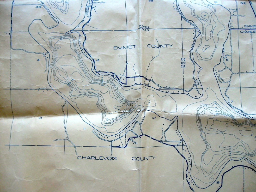
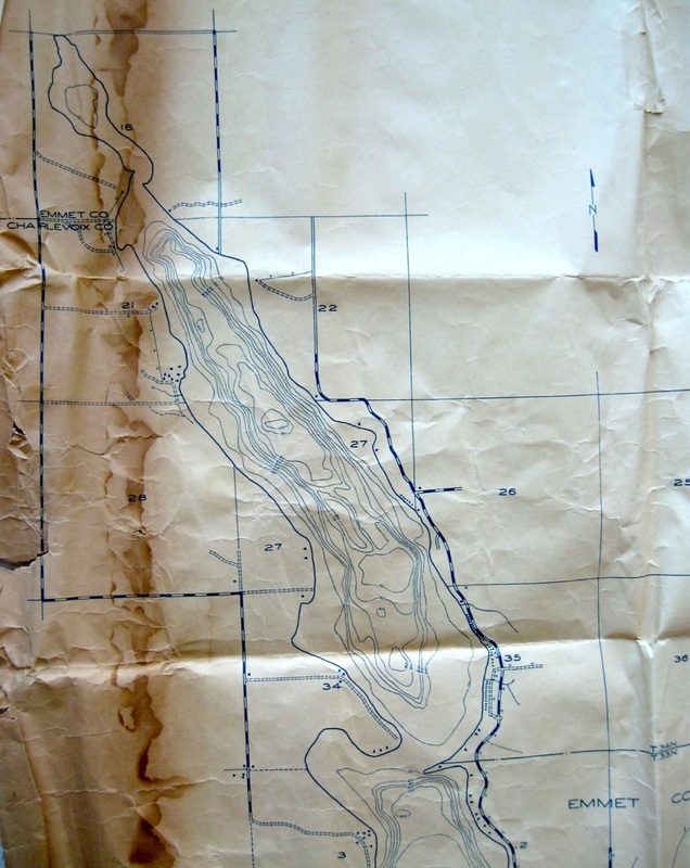
~ 1938-1939 Walloon Lake Survey and Soundings Map ~
by CCC Camp Wolverine in Nearby Chandler Township
(According to the map below, the West Arm is the deepest basin with a 100 feet sounding.)
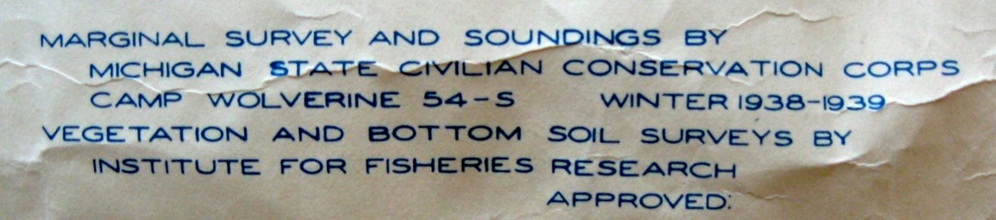
Part of the Legend as seen in the photo of the full map below
The map is about 3 feet by 4 feet in total. ~ Submitted from the Collection of Louisa Taylor
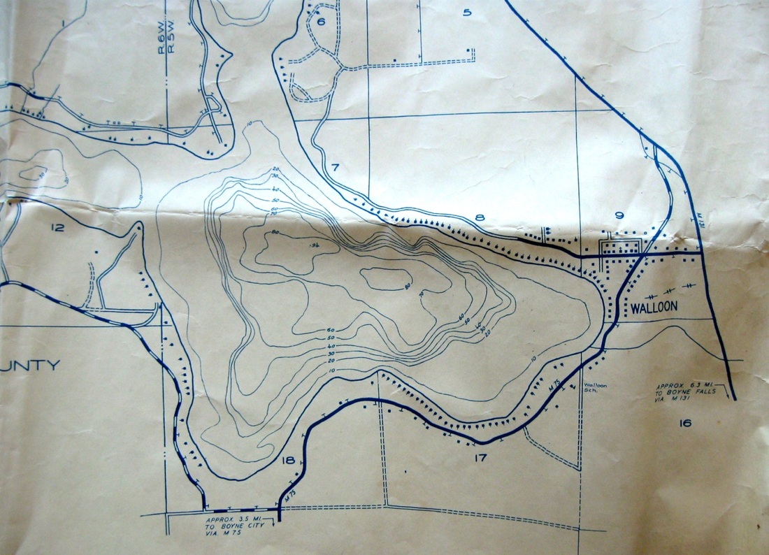
1938-1939 Survey showings of buildings surrounding Walloon Lake and the soundings showing the deepest part of this Main Basin as 94 feet
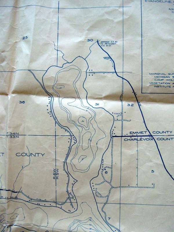
1938-1939 Survey showings of buildings surrounding Walloon Lake and the soundings showing the deepest part of this North Arm Basin as 52 feet
1938-1939 Survey showings of buildings surroundings Walloon Lake and the soundings showing the deepest part of this South Arm Basin as 80 feet
1938-1939 Survey showings of buildings surrounding Walloon Lake and the soundings showing the deepest part of this West Arm Basin as 100 feet
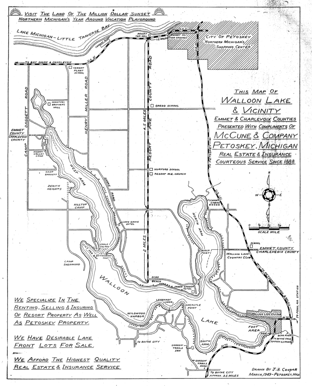
~ 1949 Walloon Lake McCune Real Estate Map ~
Walloon Lake and Vicinity (March 1949)
Compliments of McCune-Dickinson, Inc. 310 Howard Street, Petoskey, Michigan
Compare this 1949 Map to the five pages of the 1963 Map next below...
Walloon Lake and Vicinity (March 1949)
Compliments of McCune-Dickinson, Inc. 310 Howard Street, Petoskey, Michigan
Compare this 1949 Map to the five pages of the 1963 Map next below...
8 September 1949 ~ Petoskey Evening News
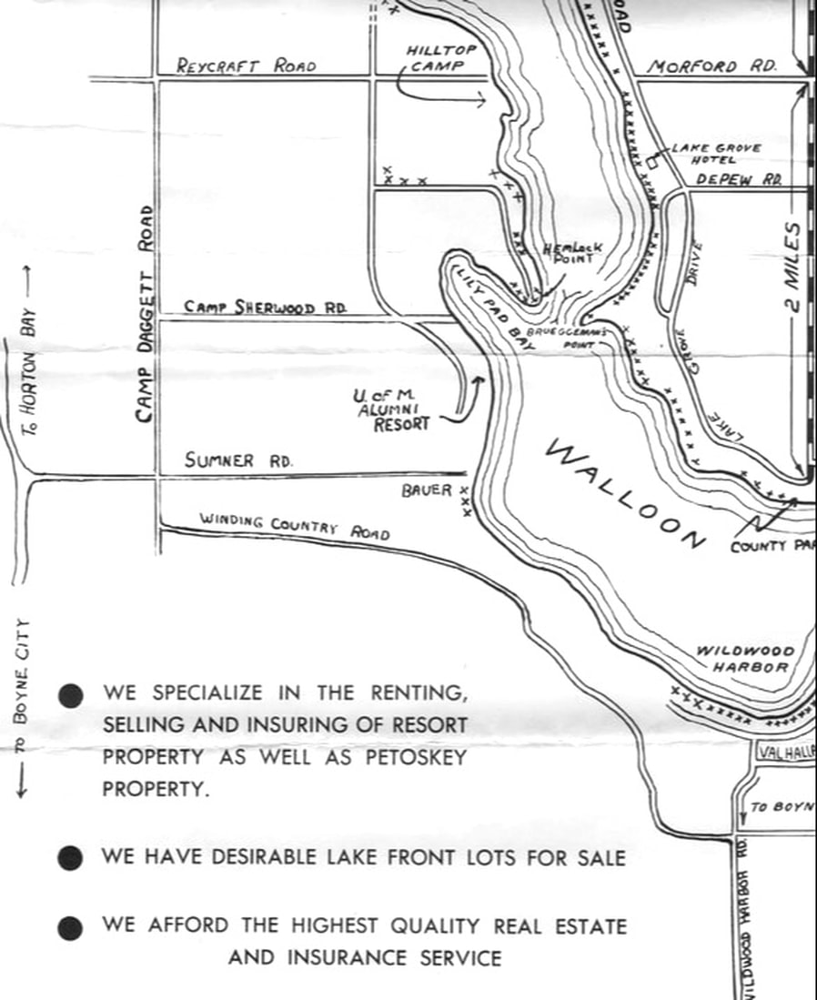
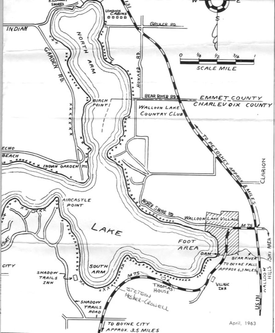
~ 1963 Walloon Lake McCune Real Estate Map ~
Walloon Lake and Vicinity (April 1963)
Compliments of McCune-Dickinson, Inc. 310 Howard Street, Petoskey, Michigan
Submitted by Local Historian Tom Sage
Compare the five pages below of this 1963 Map to the 1949 Map just above..
Below: The entire map was scanned in four sections which are posted below the complete map
for easier, close-up viewing.
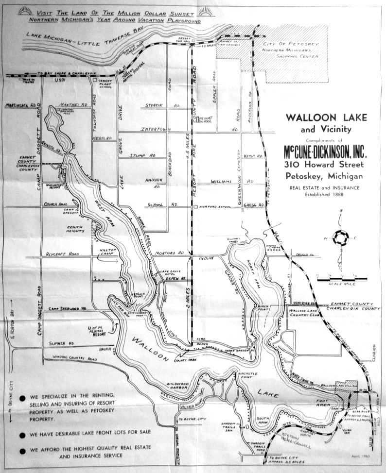
Entire Map Above Shown Below in Four Sections...
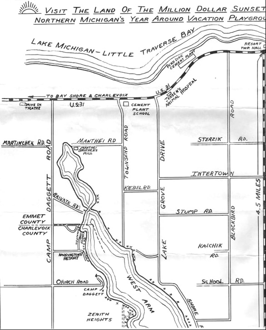
Top Left
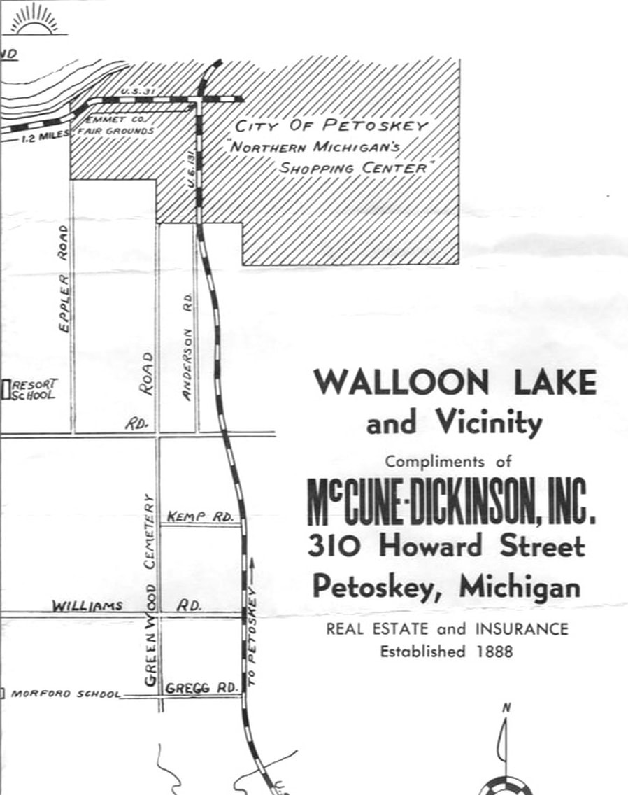
Top Right
Bottom Left
Bottom Right
~ 1961 Map of Relocation of M-75 between Boyne City and Walloon Lake ~
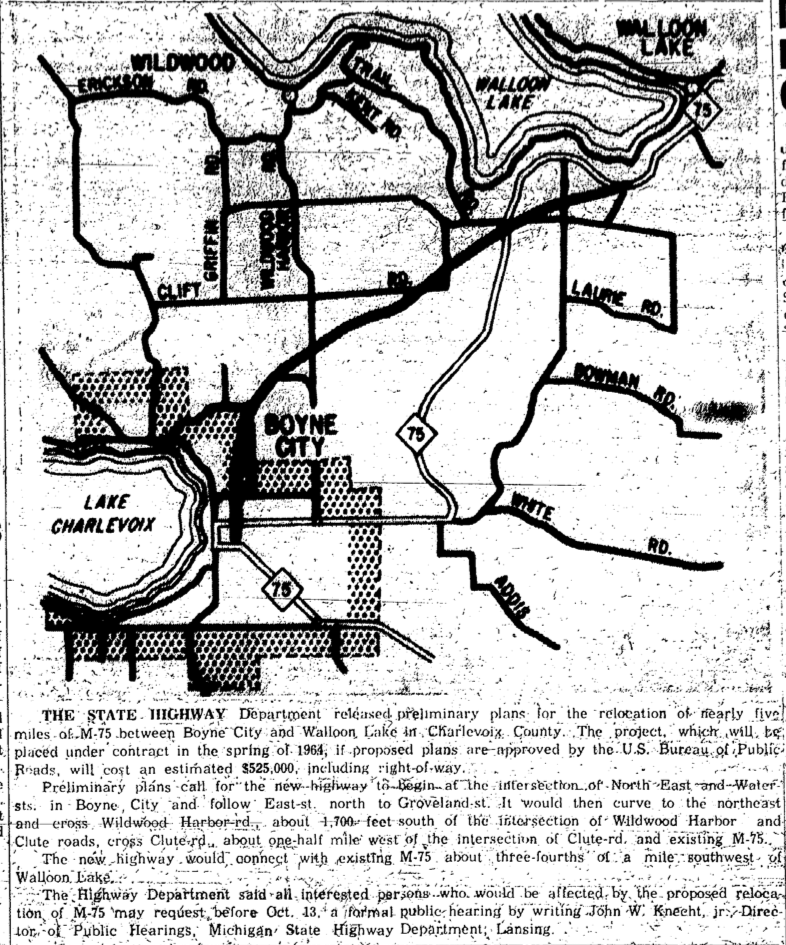
30 September 1961 ~ Petoskey News Review
Possible Late 1960s Walloon Lake Chamber of Commerce Map of Walloon Lake
used as advertising by McCune & Co. Insurance and Real Estate of Petoskey, Mich.
used as advertising by McCune & Co. Insurance and Real Estate of Petoskey, Mich.
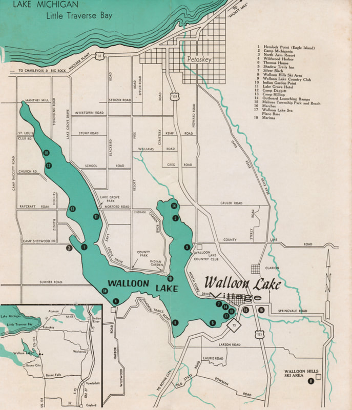
Walloon Lake Chamber of Commerce Brochure, featuring a map of Walloon Lake, used as advertising by McCune & Co. Insurance and Real Estate in Petoskey, Mich. ~ Submitted by Tom Sage
26 June 1986 ~ The Graphic
~ 1938 Melrose Township Charlevoix County MI Map ~
From Michigan Department of Conservation
Field Administration Division
The numbered lumber camps, abandoned railroad tracks, trails and good dirt roads were identified.
From Michigan Department of Conservation
Field Administration Division
The numbered lumber camps, abandoned railroad tracks, trails and good dirt roads were identified.
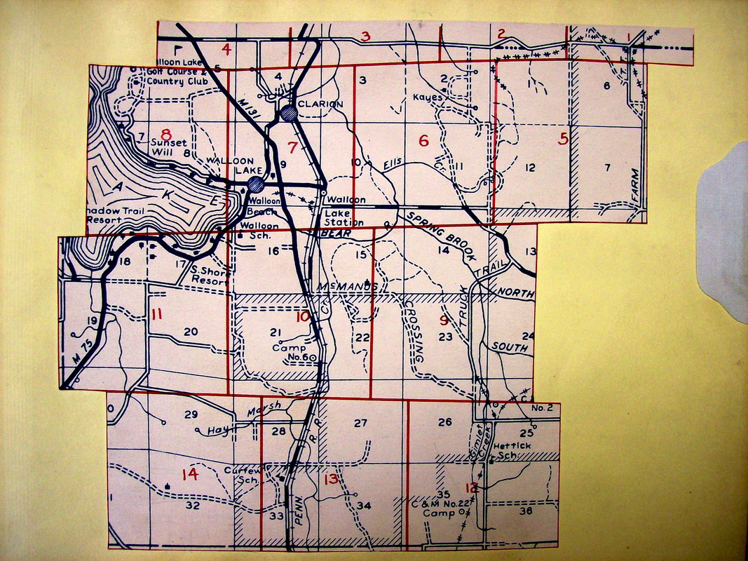
1938 Melrose Township Map
~ Charlevoix County Plat of Gov't 4 Sec b. 1.33 NR.5W. ~
(Turner, Jacob, McCune, Nickey)
(Turner, Jacob, McCune, Nickey)
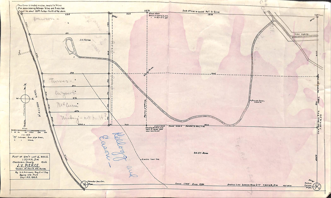
Charlevoix County Plat of Gov't 4 Sec b. 1.33 NR.5W.
Navigation Charts of Lake Charlevoix
Walloon Lake and Little Traverse Bay
1970
Walloon Lake and Little Traverse Bay
1970
LINKS
Charlevoix County 1901 Plat Book ~ Melrose Township
Charlevoix County Road Map
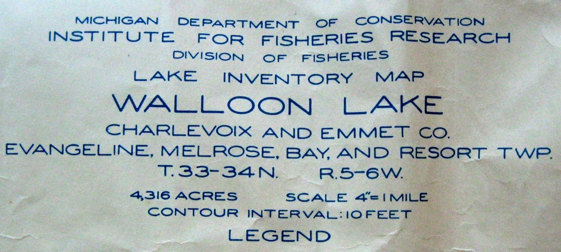
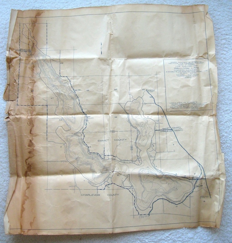
DNR ~ Institute for Fisheries Research Map for Walloon Lake
DNR ~ Institute for Fisheries Research Map for Charlevoix County
Lake Inventory Map of Walloon Lake by the Institute For Fisheries Research
Walloon Lake Fishing Map
Walloon Lake Preserve Trail Maps
The 1916 Michigan Map below is from the book... Michigan and her Great Highways Dedicated to the Dixie Highway. The book is further described as A Brief Sketch of the Earliest History of Michigan's Great Lake Region Now the Summer Land of the Middle West by Mrs. James T. Flaherty.
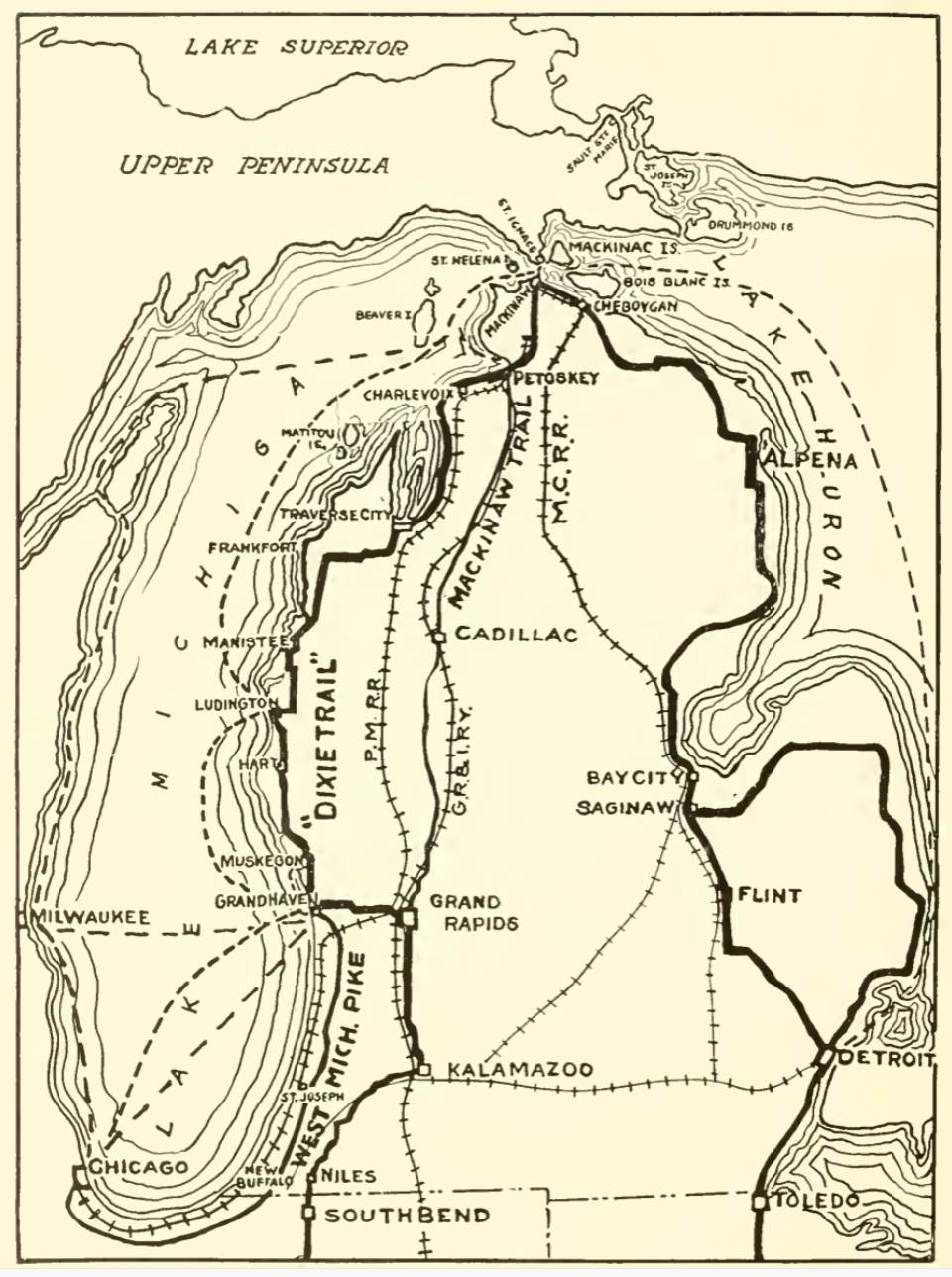
1916 MIchigan Map
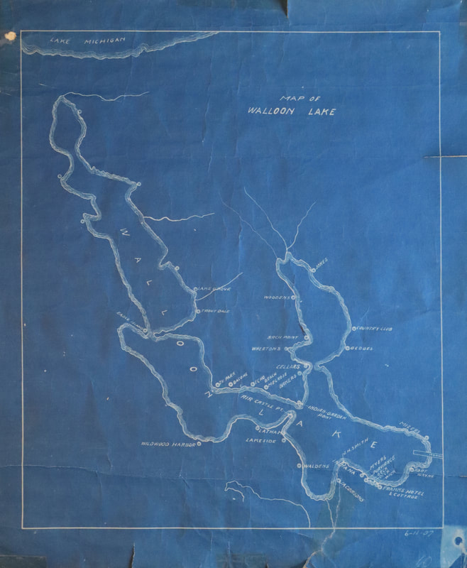
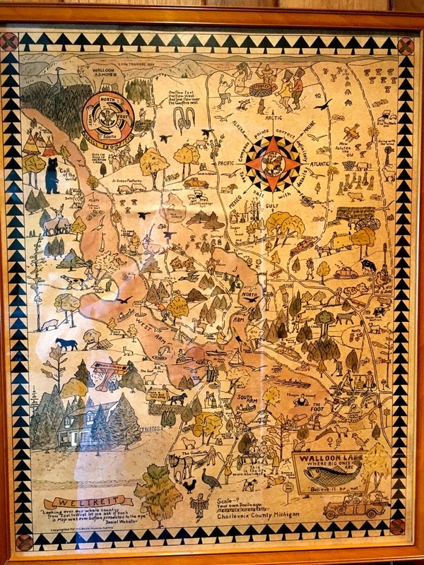
~ "A New Map of Walloon Lake" (Undated) ~
Signed: "The map drawn by Richard F. Burns"
Signed: "The map drawn by Richard F. Burns"
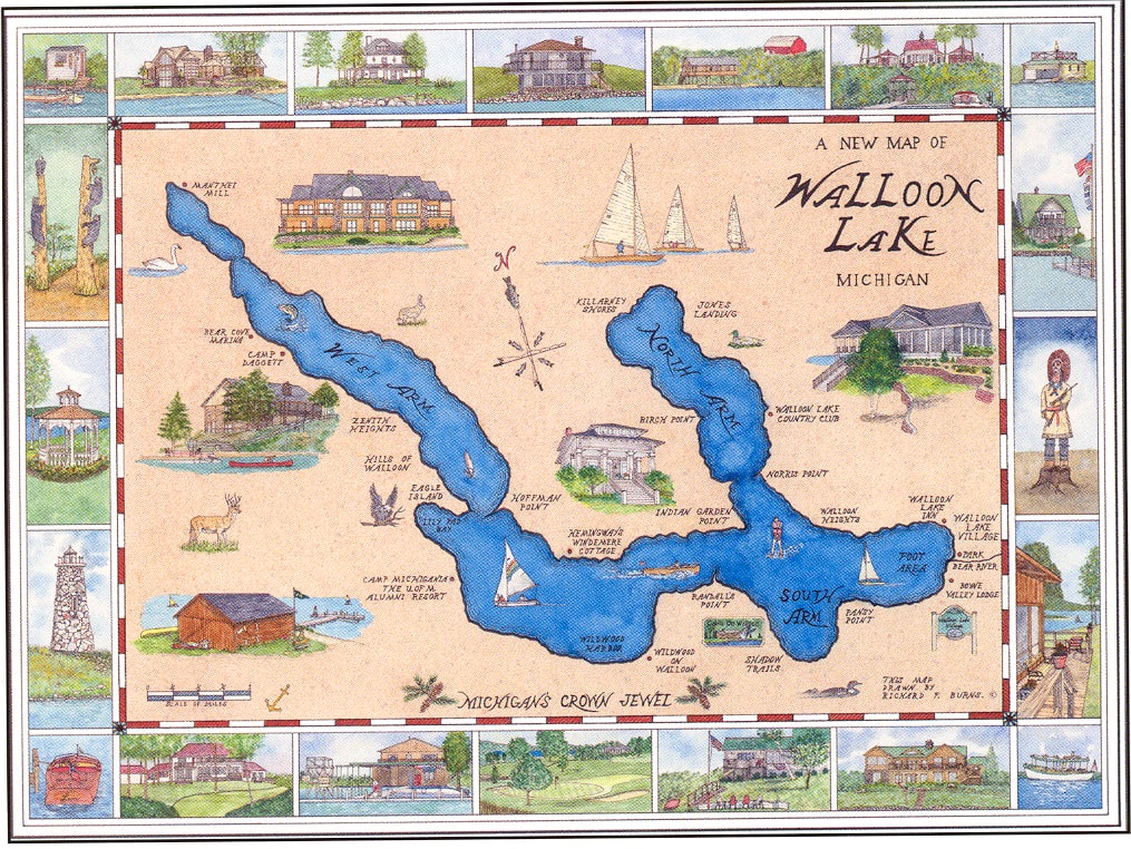
Greenwood Photo Archive Collection (Undated)
Map Below: Fall Color Tour "Walloon Lake ~ Lake Charlevoix"
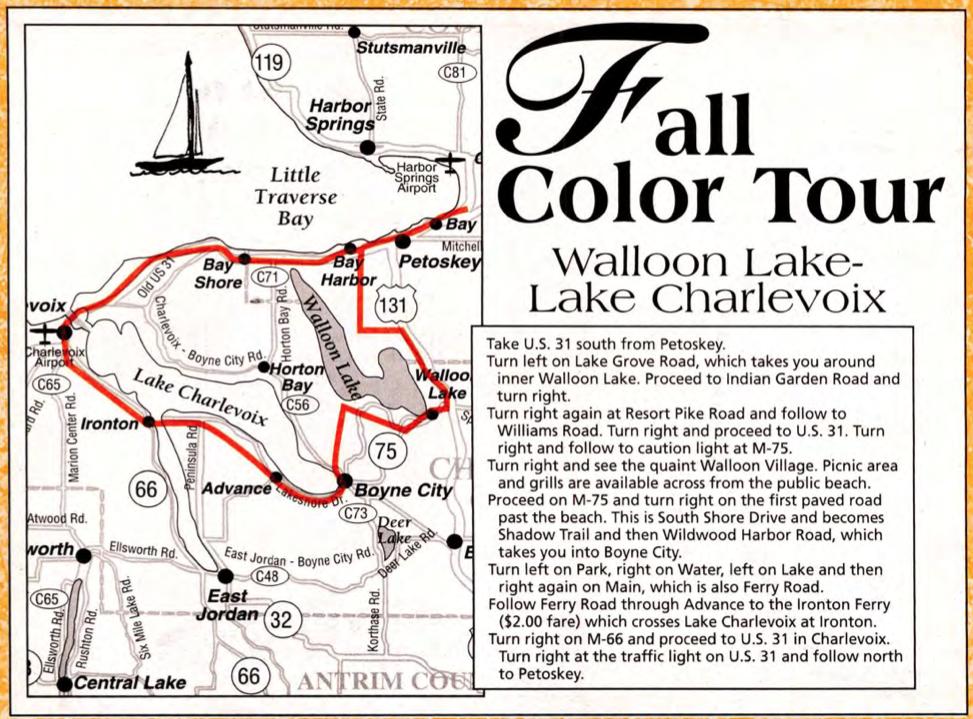
15 October 1998 ~ Emmet County Graphic
Map Below:
~ Walloon Lake Waterworks Circuit Boundary ~
2023
~ Walloon Lake Waterworks Circuit Boundary ~
2023
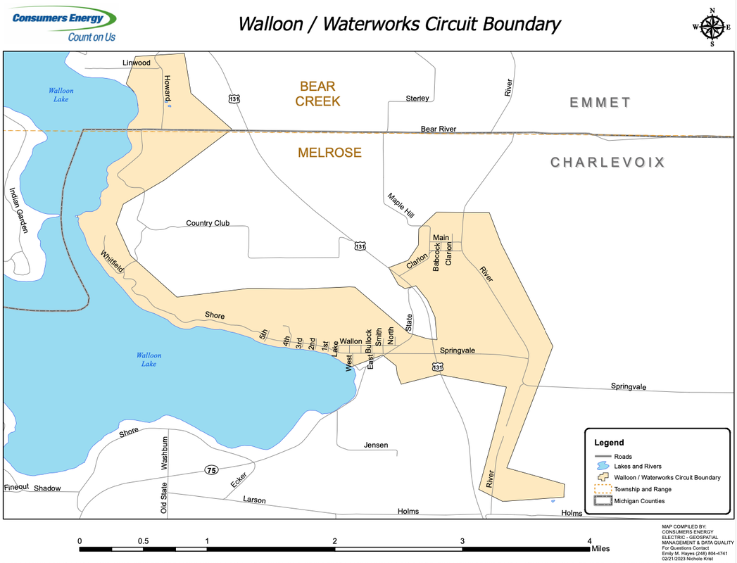
2023 ~ Compiled by Consumers Energy Electric - Geospatial Management & Data Quality
