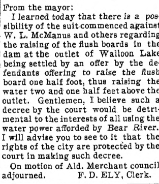
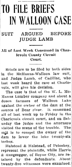
~ FLOWING WATERS OF WALLOON LAKE ~
_______________________________
_______________________________
Please do not copy the photos on this site, many of which have been submitted by private individuals...
just come back and visit the site often to view the photos.
The design and compilation of the text and photos on this site are copyrighted 2014.
just come back and visit the site often to view the photos.
The design and compilation of the text and photos on this site are copyrighted 2014.
Early 1900s
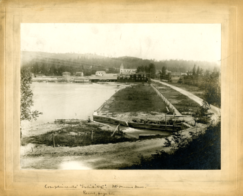
Flowing Bear River with Walloon Lake Village, and the high hillsides in the background...
Flowing Bear River with Walloon Lake Village, and the high hillsides in the background...

Greenwood Photo Archive Collection from Petoskey Newspaper (Undated)
2014
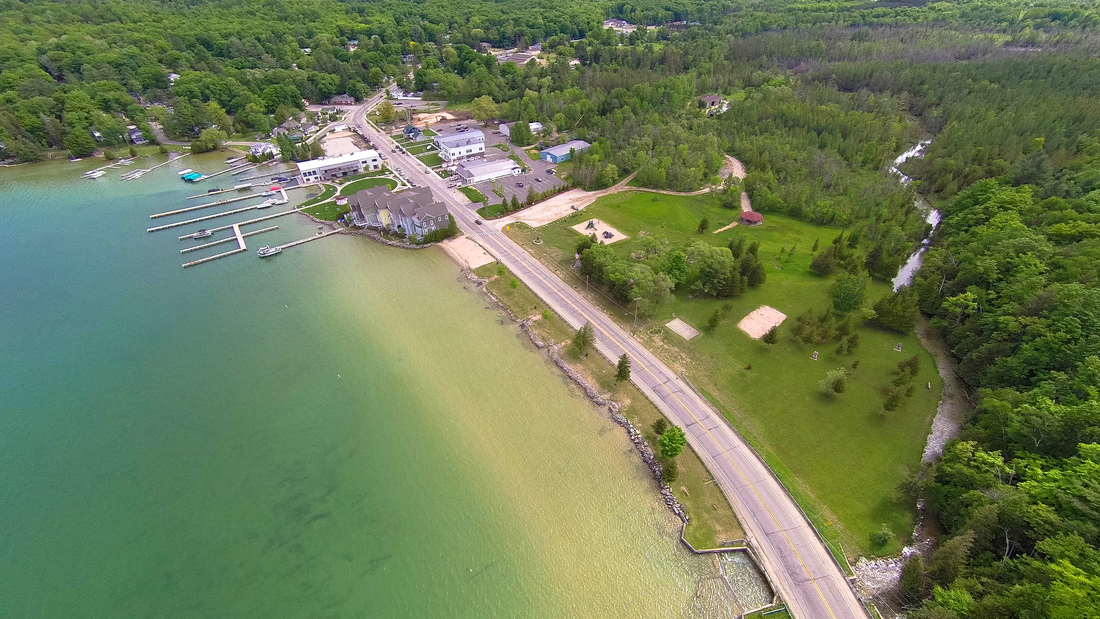
8 June 2014 ~ The only Walloon Lake outlet is the Bear River flowing out of the Walloon Lake Dam to reach Little Traverse Bay in Petoskey MI
Photo Credit: Odalaigh
Most of the largest and longest rivers in Michigan are on the west side of the lower peninsula,
including Grand Rapids' Grand River, which is the longest river in the state.
Photo Above:
Walloon Lake has the Bear River as its only outlet,
flowing over the dam at the Village of Walloon Lake,
on to Little Traverse Bay in Petoskey, Michigan.
including Grand Rapids' Grand River, which is the longest river in the state.
Photo Above:
Walloon Lake has the Bear River as its only outlet,
flowing over the dam at the Village of Walloon Lake,
on to Little Traverse Bay in Petoskey, Michigan.
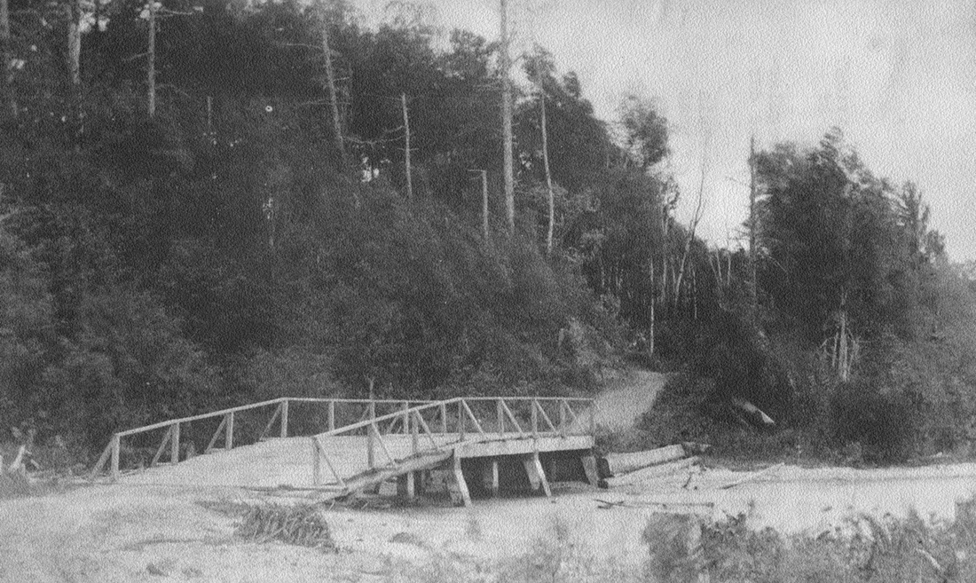
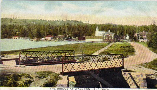
"In 1886 the township had a bridge built across Bear Rover at the foot of Bear Lake.
The Boyne City-Springvale State Road was becoming a well-used trail." ~ Unknown Author
The Boyne City-Springvale State Road was becoming a well-used trail." ~ Unknown Author
Submitted from one of the front pages from a series of Walloon Lake Community Church programs showing historic photos of the Walloon Lake area.
Early on... contention existed,
between the residents of Bear Lake (Walloon Lake) and the McManus Lumber Company,
over control of the Bear River Dam which fluctuated the lake and the river levels.
between the residents of Bear Lake (Walloon Lake) and the McManus Lumber Company,
over control of the Bear River Dam which fluctuated the lake and the river levels.
1884
Already in 1884 the Bear Lake residents were not pleased with the changes of lake level, leaving their docks and boat house high and dry, They sued Mr. McManus. The courts settled this landmark conservation case in favor of the residents.
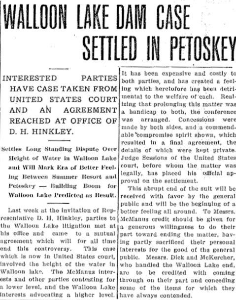
1889
Bear River Dammed Up ~ Shut off Petoskey Water Supply
Bear River Dammed Up ~ Shut off Petoskey Water Supply
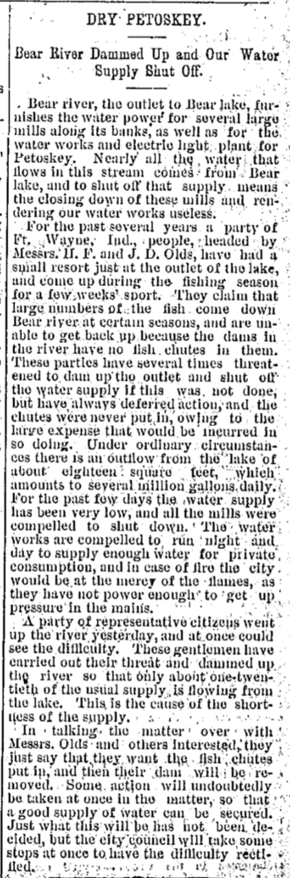
14 August 1889 ~ The Daily Resorter
|
21 August 1889 ~ The Petoskey Record
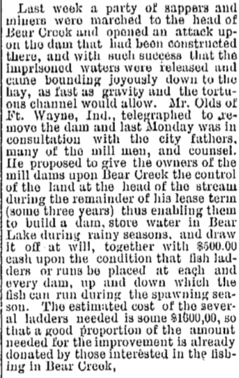
The Olds Dam was built in 1889,
replacing the McManus Dam. The new dam narrowed the dam width from 40 to 50 feet to 16 feet. All then seemed content for 10 or 11 years. BUT, in about 1900 McManus with his lumbering and Birkett with the Petoskey Fiber Paper Co. purchased the land where the river flows, plus down stream for a good ½ miles! The new owners created an adjustable dam, with layers of planks, maneuvered for their own convenience. |
CONGRESSIONAL SERIAL SET published in 1906 on page 343 describes the Walloon Lake District water:
"A well is reported to flow on the Rokopf farm on the west arm of Walloon Lake, but was not visited.
At the outlet of Walloon Lake a well 175 feet deep is reported to have flowed until it became clogged because of imperfect casing. This well is thought to have entered a gray shale at about 100 feet.
There was a flowing well at the the mill by Bear Creek at Clarion, but it has been out of use for some years, and appears to have stopped flowing, though the writer did not visit the spot to ascertain the present condition.
These wells are all located in valleys bordered by prominent drift ridges and are of value in showing the promising prospects for development of a flowing-well district in the valleys."
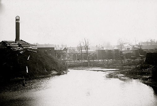
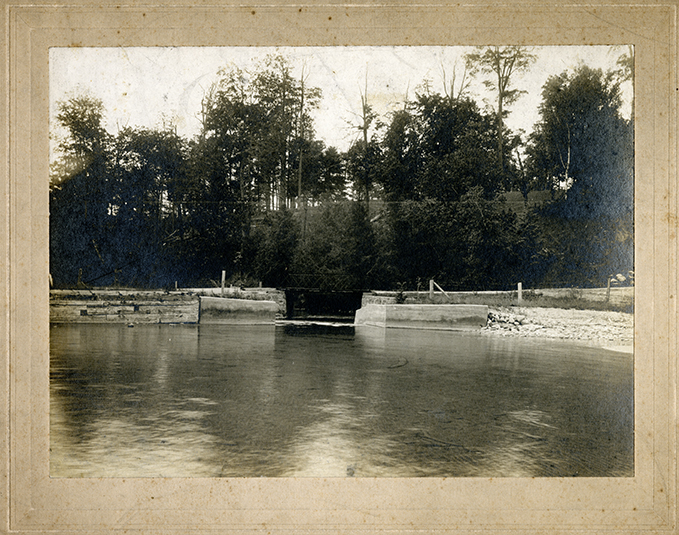
Photo Below: Bear River Dam at Walloon Lake "The Foot"

Little Traverse Historical Society Photo Collection

Little Traverse Historical Society Photo Collection (1906)
Submitted from the Collection of Eddie May

Submitted from the Collection of Marilyn Mattox

Little Traverse Historical Society Photo Collection (Undated)
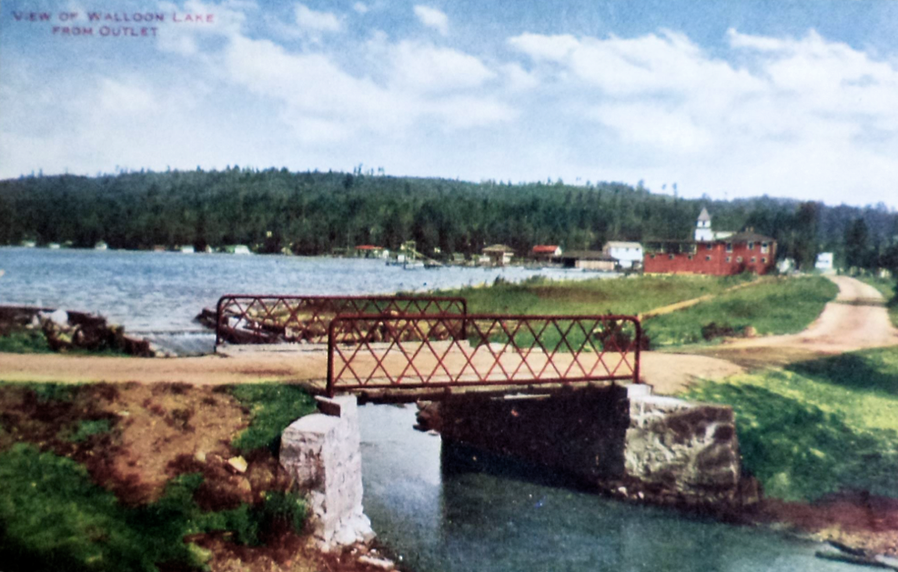
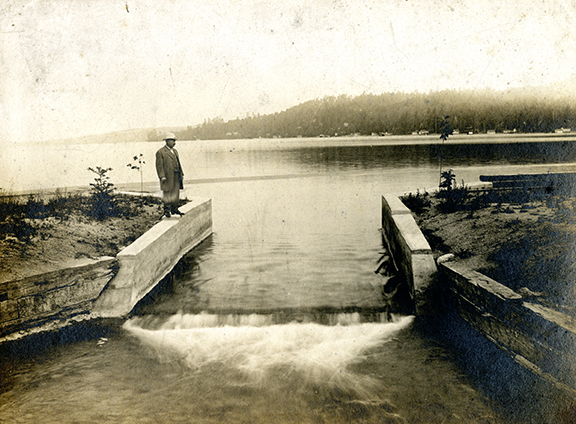
View of Walloon Lake From Outlet
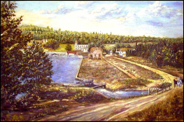
~ Copy of a large oil painting of Walloon Lake Village painted by F. Kleinhans ~ Painting owned by Suzanne Sherk
This above painting of primitive Walloon Lake Village, before many buildings existed at "The Foot",
does show the outlet for Walloon Lake running through the dam into Bear River.
does show the outlet for Walloon Lake running through the dam into Bear River.
Other photos dated about 1885 show the dam to be fairly basic and made of logs, and timber. The above painting looks very much like a photograph that was used as a "Defendant's Exhibit 2" in the 1905 lawsuit as referenced below, which attempted to "define the lake level of Walloon Lake". The lake level first began to be questioned in 1877. In that "Defendant's Exhibit 2" photograph the sidewalk on the left of the road was also shown. With this dammed up outlet being the only outlet for Walloon Lake, the effect of the dam was major for the lumbering businessmen, as well as for the people who lived along the lakeshore of Walloon Lake and needed to have an adequate lake level for their docks with boating activities. The metal bridge shown in the painting was built in 1902, and had replaced a previous old plank bridge. The District Court of the U.S. in Grand Rapids finally in 1916, established the level of Walloon Lake, although some present day Walloon Lake residents experience lake level fluctuations.

Little Traverse Historical Society Photo Collection (Undated)
Photos Below: W.L. McManus Jr. and Friend were enjoying the beach waters of Walloon Lake.

Permission to post only on this "Walloon Lake Wanderings" web site from Chris S. McManus Collection (undated)
|

Permission to post only on this "Walloon Lake Wanderings" web site from Chris S. McManus Collection (undated)
|
1903
~ THAT BEAUTIFUL McMANUS SCHEME ~
~ THAT BEAUTIFUL McMANUS SCHEME ~
As early as 9 September 1903 as expressed in The Petoskey Record article below, Petoskey Alderman McManus was hoping to be in control of the level of water in Walloon Lake. He was even trying to involve Walloon Lake's neighboring City of Petoskey in McManus' hope to make Walloon Lake his storage of power supply, to "empower him to violate the rights and damage the property of all the people on its shores by raising and lowering its level below and above its normal level more than four feet." This struggle regarding the level of water in Walloon Lake was challenged in the courts for years and years.

9 September 1903 ~ The Petoskey Record
14 September 1904 ~ The Petoskey Record
1905
McManus sued for the courts to rule if the residents had any right
to interfere with the outflow or natural level of the lake.
McManus sued for the courts to rule if the residents had any right
to interfere with the outflow or natural level of the lake.
5 July 1905 ~ The Petoskey Record
1907
The Bear River Matter Decided
The Bear River Matter Decided

6 February 1907 ~ #1 The Petoskey Record... continued next column
|
6 February 1907 ~ #2 The Petoskey Record... continued next column
|
6 February 1907 ~ #3 The Petoskey Record... continued next column
|
6 February 1907 ~ #4 The Petoskey Record... continued next column below
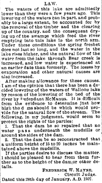
6 February 1907 ~ #5 The Petoskey Record... continued from column above
|
6 July 1908 ~ Petoskey Evening News
1909 Article Below: The new reservoir which was built to supply the village and north shore with spring water, was rapidly nearing completion, and upon completion, the pipe liner would be laid at once. The tank would hold about 40,000 gallons, sufficient for the needs of everyone. Excavating had been unusually hard as stumps and other difficulties were all removed by hand, and the men worked waist-deep in water.

23 August 1909 ~ Daily Resorter & Petoskey Evening News
1913
2 September 1913 ~ Petoskey Evening News
1914
|
Photo Below and Advertisement Article at Right:
The photo below of William L. McManus, Jr. accompanied the advertisement for his run for Democratic Candidate for Secretary of State. The article right, does tell of some of his accomplisments, but does not mention the Bear River lawsuit involving Walloon Lake's water levels and dam. 
3 November 1914 ~ Pellston Journal
|

3 November 1914 ~ Pellston Journal
|
~ McManus Lumber Mill and Bear River HISTORY ~
McManus Lumber Mill ~ Petoskey MI
|
Photo Above: Petoskey's first large industry was the lumber mill which W.L. McManus purchased from John Kilborn in 1882. The mill was operated by the McManus Family until 1934 when it ceased operation. In 1884 the mill processed 3,000,000 feet of lumber per year and employed 65 men. Many of the logs for the McManus Mill were floated down the Bear River from the Walloon Lake area.
Article Right: Not all of the logs going to the McManus Mill were delivered by the Bear River as this 1911 article wrote that 18 to 20 loads of logs were hauled down State Street hill in Petoskey each day. |

18 January 1911 ~ The Petoskey Record
|
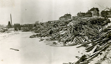
The five photos below illustrate why Mr. McManus felt the need to be in control of the Bear River as it flowed out of Walloon Lake. The river, at the right flow level, transported the McManus logs, from the Walloon Lake area, directly to his Petoskey Saw Mill to be milled.
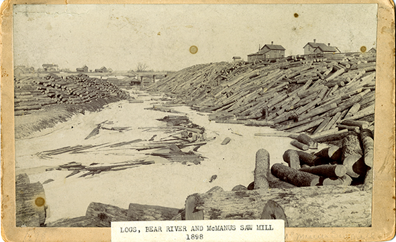
1898 ~ Logs in the Bear River near Petoskey and the McManus Saw Mill
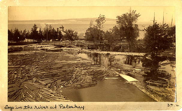
Logs in the Bear River at Petoskey
Logs next to the McManus Saw Mill
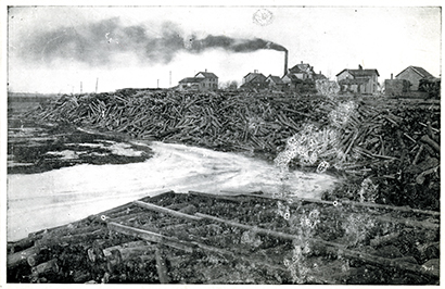
Logs Jam in the Bear River near McManus Saw Mill
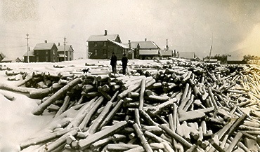
McManus Mill Logs
"About that time I was exploring down by the dam and noticed some sawlogs in the river just below the dam which had become stuck in the bank. Bill Grund, Heinie’s brother was standing there along with a couple of men wading in the stream. They had been trying to free the stuck logs and get them floating down the stream, but couldn’t get one worked loose. Bill said they would have to dynamite it and with that word I was off. I had heard my folks and especially Grandpa Carlisle talk about the dangers and risks of using dynamite, so all I could think of was how these men were going to blow the place to pieces. I set off with full speed up the hill across the bridge and ducked into a clump of trees several hundred feet away from this scene of supposed devastation. After a few minutes I heard a dull BOOM and Homer Wilde, who was with me called me back. The log was split in two and Homer said that Bill had stood on the bridge all the time. That was my first experience with dynamite, but not the last as we had to use quite a bit of it in loosening the hardpan in digging out the basement of my house."
~ James C. Whitfield, Sr.
~ James C. Whitfield, Sr.

Submitted from the Collection of Ross Renwick
|

By the Dam
|
Photo Above: The angle of the view of the dam is similar to that in the painting up above.
If anyone knows that name of this gentleman, or the little girl, please contact the webmaster of this site.
If anyone knows that name of this gentleman, or the little girl, please contact the webmaster of this site.
In 1900 Mr. McManus, and Thomas Birkett of the Petoskey Fiber Paper Company, had purchased the land with the Bear River outlet, plus about 1/2 mile downstream. They created an adjustable dam with logs, which they used to their business' benefit. Several court cases between McManus and the residents of the lake ensued over the years. In 1911 Mr. McManus and Thomas Birkett sold their interest in the dam so construction of a new dam, probably similar to the dam in the above photo could be built.

Submitted from the Collection of Ross Renwick
Photo Above:
This is the Bear River from the park side of Walloon Lake
after the water has flowed over the dam and under the road bridge.
The man on the right appears to be the same man as in the photo above this photo,
and the little girl is the same girl as in the previous photo.
I think perhaps the name of the man in the center back MAY have been Harry Taylor
because I have seen photos of a man concerned with lumbering who looks very much like the man in this photo,
and that photo labeled the man as Harry Taylor.
If anyone recognizes that name (Harry Taylor) of this gentleman please contact the webmaster of this site.
The lady and two children in this photo appear to be the same people as in
# 9 and # 10 on the unidentified photos webpage.
IF the February 1910 article below was referencing the same possible Harry Taylor in the photo above, then this photo above was taken in 1910 with the little boy held by the mother being the boy born 10 February 1910.

11 February 1910 ~ Petoskey Evening News
1 June 1910 ~ The Petoskey Record
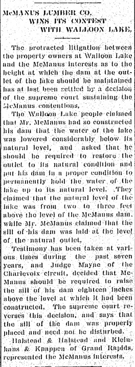
~ Protracted Litigation ~

20 April 1910 ~ The Petoskey Record
Article Above and Photo Below:
Halstead & Halstead, located in nearby Petoskey MI, represented McManus Lumber Company
for the Walloon Lake lawsuit over the level of Walloon Lake as manipulated by Mr. McManus.
Halstead & Halstead, located in nearby Petoskey MI, represented McManus Lumber Company
for the Walloon Lake lawsuit over the level of Walloon Lake as manipulated by Mr. McManus.
Petoskey MI ~ Top: Dr. N. Hart, B.N. Halstead & B.T. Halstead. Lower Right: N. Welling
12 May 1910 ~ Petoskey Evening News
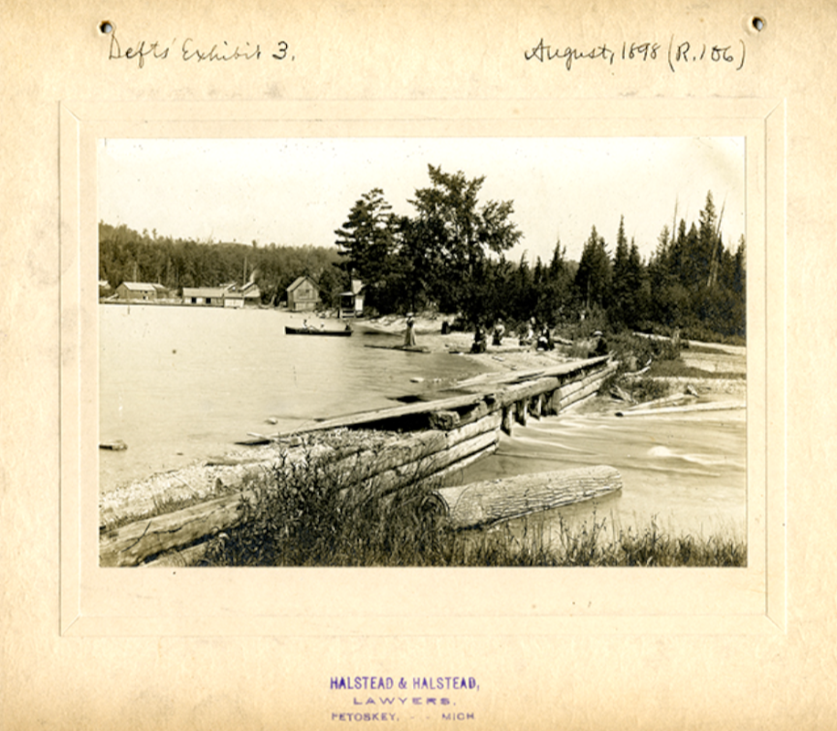
Halstead & Halstead represented the McManus interests in the 1910 trial. This photo was used as the Defendant's Exhibit 3 ~ Photo taken August 1898
20 July 1910 ~ Petoskey Evening News
"Once or twice during a summer we’d see a great raft of logs come down the lake towed by an old one-lunger boat. The rafts would be hauled to the dam where they would be broken up and several men would wade into the water and boost them over the dam to float down river to a sawmill owned by a Petoskey man, George McManus. Each summer we’d notice that along in July or August when normal evaporation and lack of rainfall would cause the lake level to be lower, there would be a period when the level would drop precipitously. No one could explain this occurrence until someone discovered that McManus, himself owned the property the dam sat on. When the lake didn’t provide enough water in the river to float his logs properly he’d send some of his men over to knock a few logs out of the old log dam. At that time it was made of logs (Photo Above). The shoreline of the lake took on a regrettable appearance with each cottager having to add several feet to his dock to have enough water to float his boat. These docks stuck way out into the lake and the big steamers, the ‘Tourist’ couldn’t get into the north arm through the ‘Narrows’. Finally the cottage-owners got together and formed the ‘Walloon Lake Association’ which brought suit against McManus. They won this suit, but McManus appealed the ruling and the case went to a a higher court where McManus won. However, the cottagers were persistent and the case went to the United States Supreme Court where they finally won and besides the court compelled McManus to sell the dam site to the Association and legally set a definite level at which the lake should be kept. A new concrete dam was built and an official marker or bench mark was set just south of it to be used as a park."
~James C. Whitfield Sr.
~James C. Whitfield Sr.
Photo Below:
Has been labeled as the Olds Dam, and referencing the fish ladder running up the left of the dam,
built in 1889.
Has been labeled as the Olds Dam, and referencing the fish ladder running up the left of the dam,
built in 1889.
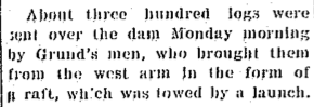
Halstead & Halstead represented the McManus interests in the 1910 trial. This photo was used as the Defendant's Exhibit 1 ~ Photo taken September 1905
Photo Below: Halstead & Halstead represented the McManus interests in the 1910 trial.
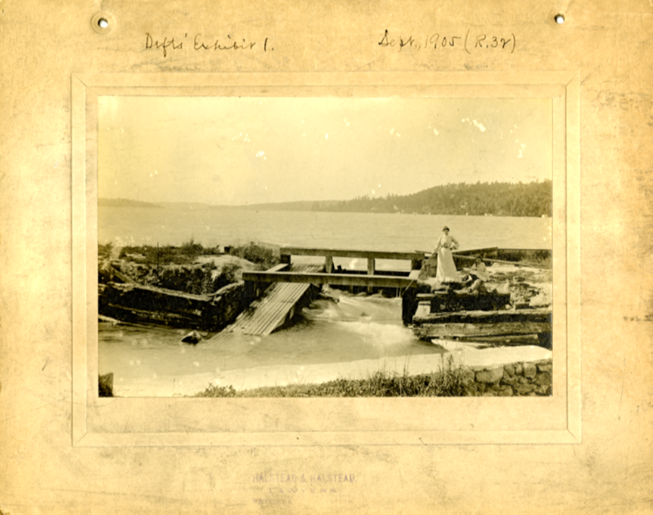
This photo was used as the Defendant's Exhibit 2 ~ Photo taken September 1905
This photo was used as the Defendant's Exhibit 2 ~ Photo taken September 1905
Halstead & Halstead represented the McManus interests in the 1910 trial. This photo was used as the Defendant's Exhibit 2 ~ Photo taken September 1905
The photo below was an undated photo, but labeled as "Recent".
Halstead & Halstead represented the McManus interests in the 1910 trial. This photo was used as the Defendant's Exhibit C... with an undated photo, but labeled as "Recent".
Little Traverse Historical Society Photo Collection (Undated)
Little Traverse Historical Society Photo Collection (Undated)
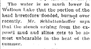
Three Photos Below: The Walloon Lake Water level lowered immensely when the dam was lowered for floating McManus' logs down the Bear River to reach Petoskey's McManus Mill. The photos below show the low water levels, and exposed beach areas.

Walloon Lake Low Water Level

Walloon Lake Low Water Level
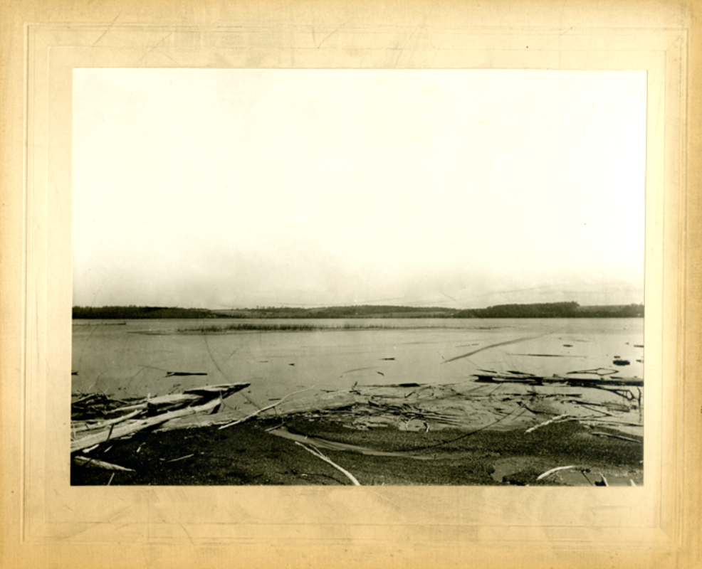
Walloon Lake Low Water Level
19 May 1911 ~ The Petoskey News

Walloon Lake Dam ~ Date Unknown
18 January 1911 ~ The Petoskey Record... Could this have been regarding the McManus Case?
|
27 April 1911 ~ The Yale Expositor (of St. Clair County MI)
|
Picturesque Walloon published 1911 described on page 12, THE VILLAGE:
"A quiet little hamlet surrounding the G.R. & I. station and steamboat landing, consists of three stores, a bowling, bath house, boat livery, boat factory, four hotels, two churches and post office. A beautiful spring of pure, cold water, one hundred feet above the village, has recently been tapped and piped to the business portion.
7 August 1913 ~ The Petoskey Record Page 3
5 September 1913 ~ The Watervliet Record
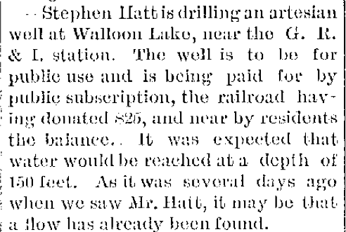
Walloon Lake Artesian Wells
Article Below Left: Rehkopf's Farm was on West Arm.
Article Below Left: Rehkopf's Farm was on West Arm.

10 July 1901 ~ The Petoskey Record
|
29 November 1901 ~ The Independent Democrat
|

Undated article...
12 January 1912 ~ Petoskey Evening News
|

18 January 1912 ~ The Petoskey Record
|
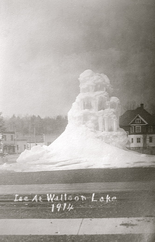
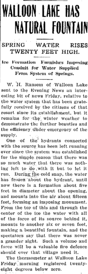
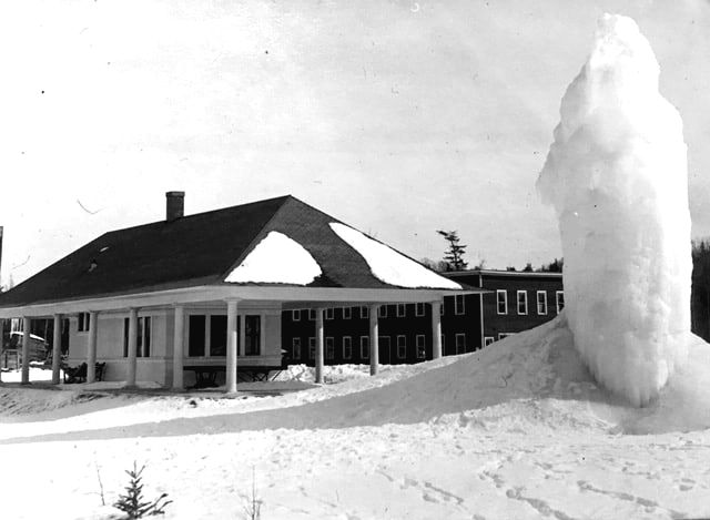
1914 Ice at Walloon Lake next to the Hass House ~ Submitted by Susie Sherk
|
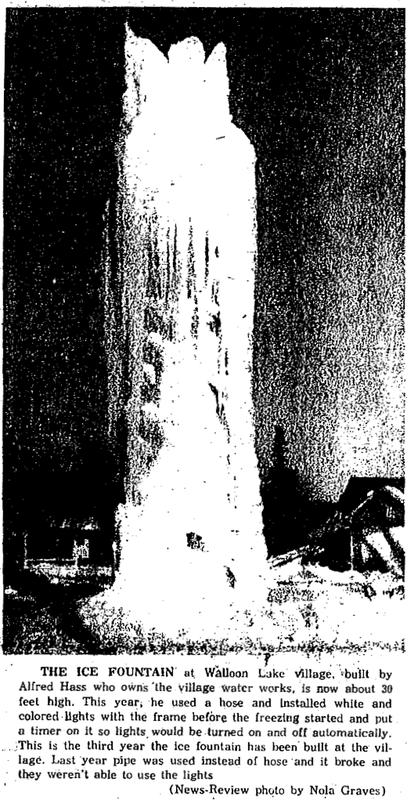
14 February 1963 ~ Petoskey News Review
|

10 January 1991 ~ The Graphic
Photo Below: The Walloon Lake Railroad Depot was located behind the free flowing water ice tower. The other building in the background was once the Michigan Incubator Company on the upper floor, and the Masters and Hass Boat Company on the lower level. More information about those businesses may be accessed on this same web site by clicking HERE.
Submitted by Linda (Lewis) Lark to be viewed only on this Walloon Lake Wanderings web site...
Michigan Reports: Reports of Cases Determined in the Supreme Court of Michigan By Michigan Supreme Court published in 1916 on pages 139 through 150 presents the issues of the case to grant an injunction "to determine the right to maintain a dam at the outlet of Walloon Lake, to which cause defendant was not a party, although he owned property which was affected by the decree, he was not concluded by the decree of the court." The dam with its flumes was affecting the level of Walloon Lake.
Page 40 begins the following description of the situation: "Walloon (formerly Bear) lake is an attractive body of water situated in both Charlevoix and Emmet counties, and is irregular in outline, consisting of two connected parts or arms. It lies in an elevated basin about 80 feet above the level of Lake Michigan, near and to the south of Little Traverse Bay, surrounded by rugged hills, has a comparatively limited tributary watershed, the extent of its drainage area being about 42 square miles. It is fed principally by springs and rainfall, a number of small streams also emptying into it. The larger arm is about 12 miles long with an average width of 1 1/2 miles, while the northerly and smaller arm is about 3 1/2 x 1/2 miles in extent. The outlet is at its southeastern extremity, where it empties into Bear creek (or river), through which, curving to the north, its waters meander into Little Traverse bay at Petoskey, some 8 miles distant. The location, beauty, and attractive environments of this lake are such that since about the year 1875 it has been recognized and more or less frequented as a summer resort for health and pleasure, assuming increasing importance in that respect. To that end private cottages, boathouses, and docks have been built at places along its shores, while craft to navigate its waters and places for public accommodations and entertainment have been provided. So far as indicated the great, if not the only, disturbing element to the peace and pleasure of those who dwelt or resorted there was the level of this lake which, either through natural causes or by the industry of man, has at times risen and fallen, thereby contracting and expanding its littoral outlines to the serious confusion and inconvenience of those who sought to dwell upon its shores. This has been ascribed by parties affected to the erection and manipulation of a dam, or dams, at the outlet of the lake at the head of Bear creek, by those owning or controlling the shore at that point, from which has resulted contention and litigation since 1902. The suit of Hass and 17 other shore owners, with summer homes upon the lake, against McManus and associates, owning and controlling the so-called McManus dam, extended over a period of about 7 years and was finally decided by this court in May 1910. Hass v. McManus, 161 Mich. 372 (126 N.W. 462)."
Page 40 begins the following description of the situation: "Walloon (formerly Bear) lake is an attractive body of water situated in both Charlevoix and Emmet counties, and is irregular in outline, consisting of two connected parts or arms. It lies in an elevated basin about 80 feet above the level of Lake Michigan, near and to the south of Little Traverse Bay, surrounded by rugged hills, has a comparatively limited tributary watershed, the extent of its drainage area being about 42 square miles. It is fed principally by springs and rainfall, a number of small streams also emptying into it. The larger arm is about 12 miles long with an average width of 1 1/2 miles, while the northerly and smaller arm is about 3 1/2 x 1/2 miles in extent. The outlet is at its southeastern extremity, where it empties into Bear creek (or river), through which, curving to the north, its waters meander into Little Traverse bay at Petoskey, some 8 miles distant. The location, beauty, and attractive environments of this lake are such that since about the year 1875 it has been recognized and more or less frequented as a summer resort for health and pleasure, assuming increasing importance in that respect. To that end private cottages, boathouses, and docks have been built at places along its shores, while craft to navigate its waters and places for public accommodations and entertainment have been provided. So far as indicated the great, if not the only, disturbing element to the peace and pleasure of those who dwelt or resorted there was the level of this lake which, either through natural causes or by the industry of man, has at times risen and fallen, thereby contracting and expanding its littoral outlines to the serious confusion and inconvenience of those who sought to dwell upon its shores. This has been ascribed by parties affected to the erection and manipulation of a dam, or dams, at the outlet of the lake at the head of Bear creek, by those owning or controlling the shore at that point, from which has resulted contention and litigation since 1902. The suit of Hass and 17 other shore owners, with summer homes upon the lake, against McManus and associates, owning and controlling the so-called McManus dam, extended over a period of about 7 years and was finally decided by this court in May 1910. Hass v. McManus, 161 Mich. 372 (126 N.W. 462)."
During the times of the "dam dispute", the dam was blown up several times. An old news article stated: "McManus knocked out the dam a few times when he needed more water and so an armed patrol was secured to protect the dam in times of low water."
Page 120 in Inland Lakes of Michigan By Irving Day Scott originally published in 1921 described the connection of Walloon Lake with the flowing water:
"Unfortunately, from the standpoint of the resorters, the level of the lake has been subjected to serious fluctuations by the use of the water for power. A dam was constructed to regulate the flow of water throughout the year, and the result has been a serious lowering of the level during the summer months. This has been done since the lake developed into a summer resort, causing great inconvenience and loss of property to the cottagers, and has been the subject of long litigation. The height of the dam has been fixed by law but the lake has not been visited by the writer since that time."
"Unfortunately, from the standpoint of the resorters, the level of the lake has been subjected to serious fluctuations by the use of the water for power. A dam was constructed to regulate the flow of water throughout the year, and the result has been a serious lowering of the level during the summer months. This has been done since the lake developed into a summer resort, causing great inconvenience and loss of property to the cottagers, and has been the subject of long litigation. The height of the dam has been fixed by law but the lake has not been visited by the writer since that time."
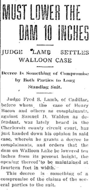
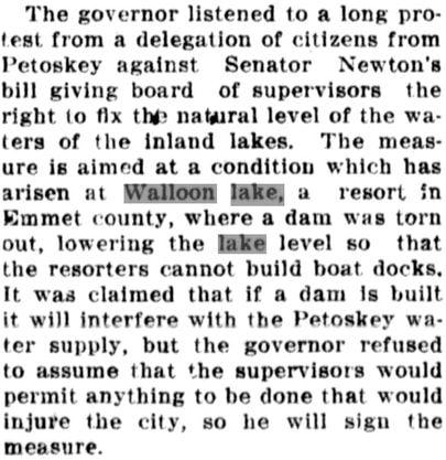
The level of the lake and the height of the dam continued to irritate either the lake people or the downriver businessmen, depending which side was being adversely affected, until the final lawsuit which took place in 1916 (See Article Below Right). All flowed smoothly then until 1950 when the old dam had deteriorated so that a new one had to be built. Frank "Burt" Burns was paid to build a new dam... then, he had to rebuild the south side in 1965. Each time, the dam height was the same as the previous dam. A fish screen was placed on the top of the dam in 1963 to hold the lake's planted fish. Then the screen was removed in 1974, only to be replaced again in 1982, fearing the fish were again leaving the lake.
22 July 1916 ~ Petoskey Evening News & Daily Resorter
|
28 July 1916 ~ The Charlevoix County Herald
|

1 October 1936 ~ Northern Michigan Review article continued below...

1 October 1936 ~ Northern Michigan Review article continued from above...
Photo Below: James "Russell" Spalding was standing on part of the Walloon Lake dam where the outlet to the lake empties into the Bear River. He lived just down the road a little at the Spalding's home, the previous Sunset Lodge located beside the Spalding's General Store right at The Foot. On the right side of the road behind the pole, the very dark building is the Walloon Lake Post Office located right next to the Spalding's home. Buildings behind Russell to the left, extending into the water, and some on the land, were possibly the dock or boat livery, a bath house, or the Grey Gull which the Starr Family owned. Probably the side of the one building is Browers General Store. Russell lived at home until he went into the military in 1942, and was killed in 1943, so this photo below may have been taken in the late 1930s or very early 1940s. It is unclear what sort of wooden structure Russell was standing on in the dam area... a fish ladder, or a part of the dam itself? Anyone know for sure?
James "Russell" Spalding before 1942. ~ Submitted from the Collection of Ross Renwick
Photo Below:
10 March 1940 ~ Louise Gruler and ? stood beside the Bear River at The Foot of Walloon Lake.
10 March 1940 ~ Louise Gruler and ? stood beside the Bear River at The Foot of Walloon Lake.

10 March 1940 ~ Louise Gruler (married Arthur Stevens) and ? stood beside the Bear River at The Foot of Walloon Lake. ~ Submitted from the Album of Arthur Stevens

11 September 1950 ~ Petoskey Evening News
1951
5 May 1951 ~ Otsego County Herald Times
|
5 May 1951 ~ Otsego County Herald Times
|

5 May 1951 ~ Otsego County Herald Times
1952
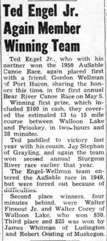
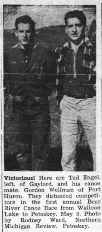
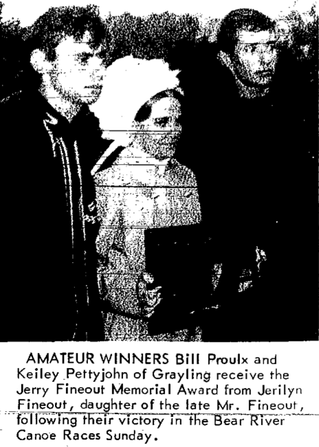
The map in the Upland Societies of Petoskey-Walloon Lake Region book on page 29 shows the location of Walloon Lake with the flow of the Bear River running into Little Traverse Bay of Lake Michigan. Years ago when the Bear River Canoe Race was an exciting event, the race was supposed to have been 18 miles long for the boys and men. The girls started at Walbmeme/Wau-meme/Wabmeme from which the distance was thought to have been 6 miles from there to the Stadium Bridge on Standish Avenue in Petoskey, Michigan. Don Simons, 90 years old in 2014, provided this spelling for Walbmeme. He attended school in the now non-existent Walbmeme logging village. Don's teacher was Mrs. Robinson. James Whitfield, Sr., spelled the name as Wau-meme. Other news articles have spelled the name as Wabmemee, with the double "e" on the end. Walloon Lake resident Ken Klumpp tells that he and friend Ed Schroeder participated in the Bear River Canoe race, and they broke both paddles.
The Petoskey Evening News newspaper photo below shows a sign promoting the second annual Walloon-Petoskey Canoe Race in 1952. Louisa Taylor had this newspaper article which had become scrunched over the years. Louisa told that, like the names hand written on the article, Nancy Cotanche, Louisa Taylor, and Sandy Hand, Walloon Lake youngsters would borrow a canoe from Ted McCutcheon Sr., paddle from his quonset hut marina to the Walloon Lake outlet, portage over the road, and head down the Bear River. Louisa said that Ted McCutcheon had hand carved a small canoe with three figures in the canoe, representing the three girls, Nancy, Louisa, and Sandy, much the size as seen in the newspaper photo. Louisa, now deceased, had wondered if the carved canoe might still exist?
The Petoskey Evening News newspaper photo below shows a sign promoting the second annual Walloon-Petoskey Canoe Race in 1952. Louisa Taylor had this newspaper article which had become scrunched over the years. Louisa told that, like the names hand written on the article, Nancy Cotanche, Louisa Taylor, and Sandy Hand, Walloon Lake youngsters would borrow a canoe from Ted McCutcheon Sr., paddle from his quonset hut marina to the Walloon Lake outlet, portage over the road, and head down the Bear River. Louisa said that Ted McCutcheon had hand carved a small canoe with three figures in the canoe, representing the three girls, Nancy, Louisa, and Sandy, much the size as seen in the newspaper photo. Louisa, now deceased, had wondered if the carved canoe might still exist?

1952 ~ Submitted by Louisa Taylor

10 April 1952 ~ Petoskey Evening News

13 May 1952 ~ Petoskey Evening News
1953

21 May 1953 ~ Otsego County Herald Times
1955

31 August 1955 ~ Petoskey News Review

23 September 1955 ~ Petoskey News Review
1956
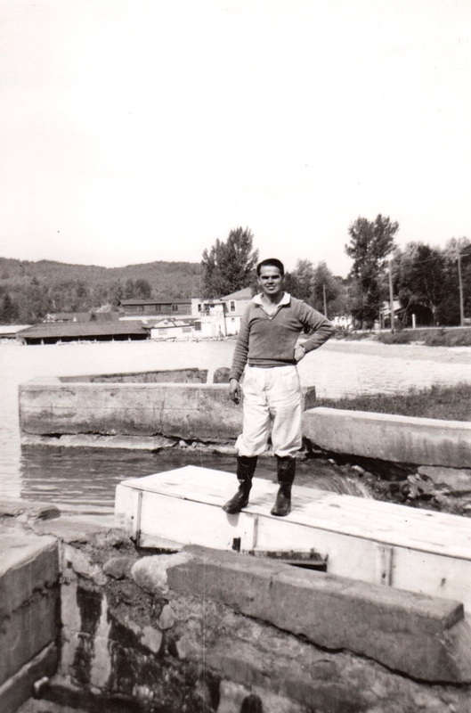
1956 photo below includes: Barb Burns, Ted McCutcheon Jr., and Pinky McCutcheon
canoeing down the Bear River near where the river flows from the Walloon Lake outlet.
Notice the snow on the hillside.

Spring 1956 ~ Photo taken by Ted McCutcheon Sr.
1969

20 May 1969 ~ Petoskey News Review
20 May 1969 ~ Petoskey News Review
22 May 1969 ~ Petoskey News Review
1970s

1970s ~ North Country News
The map in the Upland Societies of Petoskey-Walloon Lake Region book on page 29 shows the location of Walloon Lake with the flow of the Bear River running into Little Traverse Bay of Lake Michigan. Years ago when the Bear River Canoe Race was an exciting event, the race was supposed to have been 18 miles long for the boys and men. The girls started at Walbmeme/Wau-meme/Wabmeme from which the distance was thought to have been 6 miles from there to the Stadium Bridge on Standish Avenue in Petoskey, Michigan. Don Simons, 90 years old in 2014, provided this spelling for Walbmeme. He attended school in the now non-existent Walbmeme logging village. Don's teacher was Mrs. Robinson. James Whitfield, Sr., spelled the name as Wau-meme. Other news articles have spelled the name as Wabmemee, with the double "e" on the end. Walloon Lake resident Ken Klumpp tells that he and friend Ed Schroeder participated in the Bear River Canoe race, and they broke both paddles.

24 January 1949 ~ Petoskey Evening News

11 November 1982 ~ Petoskey News Review

18 August 1989 ~ Petoskey News Review
Postcard below from the Late 1960s showing the beach, and the dam, but no fish guard.

Postcard from the Late 1960s showing the beach, and the dam ~ Photograph by Helen Gaskin of Charlevoix MI

Greenwood Photo Archive Collection from Petoskey Newspaper (July 1969)

Postcard received in 1977
The winter of 2013-2014 was very cold with a record amount of snowfall...
all leading to a large water run-off from Walloon Lake into Bear River on 4 May 2014,
as can be viewed in the slide show below.
New stream crossing planned in Melrose Township
November 15, 2011|Sheri McWhirter Petoskey News Review
BOYNE CITY — Charlevoix County road officials will partner with a local environmental group to remedy a troublesome stream crossing complicated by beavers.
Road commissioners on Monday discussed a possible $40,000 project at the Holms Road crossing at Hay Marsh Creek, a tributary to the Bear River in Melrose Township. A grant from the U.S. Environmental Protection Agency’s Great Lakes Restoration Initiative may pay for a new culvert and restored stream banks, an effort by the Tip of the Mitt Watershed Council.
“We’ve done projects with these folks before and it always turned out well,” said Pat Harmon, road commission manager.
Documents show engineering plans will be drawn up over the winter and permits will be applied for in the spring. The only local match to the grant is the road commission’s oversight work.
“That crossing has been a problem for years. The pipe is way too short. It’s a mess,” Harmon said. “The pipe that will go in there is much bigger.”
Beavers and their dams have been a “huge problem” at the site and road workers installed grates across the culvert entrance and exit to keep the critters out, Harmon said.
Jim Vanek, road commission engineer, said the state Department of Environmental Quality will require a complete hydrology study to accompany this project. The stream’s drainage area is larger than two acres, he said.
Jennifer Gelb, Tip of the Mitt’s restoration ecologist, could not be reached for comment.
The project’s overall goal is intended to reduce non-point source pollution in Little Traverse Bay, Lake Michigan’s fourth largest bay. It will be part of a federally approved watershed protection plan.
Russ MaGee, road commissioner, said he is in favor of the grant-funded project.
“If we can do it without getting up to our necks, let’s do it,” MaGee said.
The project is expected to be completed by October next year, documents show.
Winter water quality monitoring event will gather data on Walloon Lake watershed
Morgan Sherburne for Petoskey News Review| February 13, 2013
Northern Michigan's streams might be blanketed with a layer of snow, but you'll still find Kevin Cronk and a team of volunteers poking around in a winter stream on Saturday, Feb. 16. Cronk, monitoring and research coordinator at Petoskey's Tip of the Mitt Watershed Council, and his team will be looking for aquatic life in a small tributary to Schoof's Creek at the Little Traverse Conservancy's Bubbling Spring Nature Preserve. Cronk will use the data he and his volunteers collect in order to paint a picture of the wetlands and tributaries surrounding Walloon Lake.
Northern Michigan's streams might be blanketed with a layer of snow, but you'll still find Kevin Cronk and a team of volunteers poking around in a winter stream on Saturday, Feb. 16. Cronk, monitoring and research coordinator at Petoskey's Tip of the Mitt Watershed Council, and his team will be looking for aquatic life in a small tributary to Schoof's Creek at the Little Traverse Conservancy's Bubbling Spring Nature Preserve. Cronk will use the data he and his volunteers collect in order to paint a picture of the wetlands and tributaries surrounding Walloon Lake.

6 March 1967 ~ Petoskey News Review
6 March 1967 ~ Petoskey News Review
|
Posted in the Petoskey News Review ~ 22 November 2013
2013 Melrose Township proposes to purchase the Walloon Lake Water System as put forth in this public posting. |
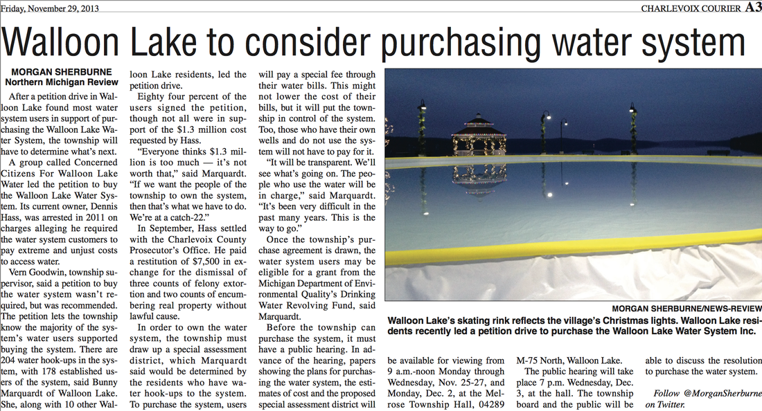
29 November 2013 ~ Charlevoix Courier
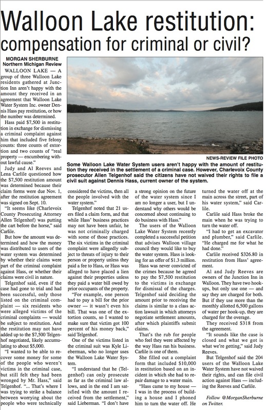
6 December 2013 ~ Petoskey News Reveiw

26 February 2014 ~ Petoskey News Review (Part 1)

26 February 2014 ~ Petoskey News Review (Part 2)
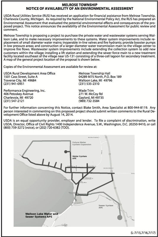
In connection with the expansion and construction of a new sewer system,
Melrose Township is applying for a U.S. D.A. Grant/Loan.
Melrose Township is applying for a U.S. D.A. Grant/Loan.

13 June 2014 ~ Petoskey News Review
16 July 2014 ~ Petoskey News Review
|

29 October 2014 ~ Petoskey News Review
|
~ Antique Bridge over Bear River Comes Down ~
1983
1983

12 September 1983 ~ Petoskey News Review
~ Flowing Water in the Form of Sewage ~
2001
2001

8 March 2001 ~ Petoskey News Review
~ Bear River off Springvale Road ~

1 January 2019 ~ Photography of "Alex Childress Photo" posted here with permission...
Photo Above: Alex Childress' additional work also may be viewed at Alex Childress Photo.
1905 Map Showing Distribution of Flowing-Well Districts and Waterworks
Walloon Lake Park showing Bear River ~ Digital Infrared Photo
Michigan Debates Putting Groundwater into a Public Trust
Walloon Lake Aquatic Vegetation Survey 2013 ~ Tip of the Mitt Watershed Council
